Most Dangerous Spot in Donbas Still Under Threat
How fighting on both sides of the Donestk Water Filtration Station is putting an entire regional population atrisk
Most Dangerous Spot in Donbas Still Under Threat
How fighting on both sides of the Donestk Water Filtration Station is putting an entire regional population at risk

The Donetsk Filtration Station (DFS) continued to see heavy fighting in close proximity to this key point of critical infrastructure. Through a stationary camera at the DFS, the Organization for Security and Co-operation in Europe’s Special Monitoring Mission (OSCE SMM) to Ukraine recorded several instances of ceasefire violations from both Russian-led separatists from the so-called Donetsk People’s Republic (DNR) and the Ukrainian Armed Forces (UAF) at the facility over the past weeks, providing a visual example of a repeatedly reported issue.
Footage from the OSCE SMM video showing ceasefire violations at the DFS on the nights of November 9 and 10, revealed the likely weapons that are being used in the area. Several explosions, likely from artillery banned by the Minsk agreements, can be seen in the video. Note that the camera is facing south, placing the “DNR” on the left and UAF on the right.

In the image above, fire is traveling in a straight line, which is typically direct fire from a likely large calibre weapon (possibly a BMP, anti-tank guided missile [ATGM] or rocket propelled grenade [RPG]).

The animation above shows a tracer making contact and deflecting upwards. Given the fact that the video shows what appears to be a single, larger calibre, shot, it is highly likely that this is from a vehicle, possibly a light armored vehicle, or BMP.

Towards the end of the video, the frequent explosion pattern indicates that fire is highly likely from a 9K51 BM-21 “Grad” 122mm multiple launch rocket system (MLRS), notoriously indiscriminate weapons also banned by the Minsk agreements.
A second video posted by the OSCE SMM shows an explosion very close to the camera.
At 02:18 on 15 November, the SMM camera at the Donetsk Filtration Station recorded an outgoing round from an undetermined weapon 0.5–1.5km south and a subsequent incoming explosion very close to the camera. The camera remained operational but due to security considerations the SMM has not been able to visit the camera site for an assessment of possible damage.
The Donetsk Filtration Station (DFS)
As @DFRLab previously reported, close opposing military positions lead to heavy fighting in proximity to the Donetsk Filtration Station (DFS) continues to pose a pressing threat to civilian life.
https://twitter.com/OSCE_SMM/status/931490525059751936
The facility nearly faced a catastrophic accident last week when a chlorine pipeline was damaged in crossfire. As @DFRLab previously reported, the large stores of liquified chlorine gas at the DFS pose a potential for a large-scale civilian and environmental incident. If the chlorine gas were hit, it could cause clouds of poisonous gas to spread into the nearby residential areas, posing a deadly risk to everyone in the immediate area (approximately a 200m radius, depending on wind and other weather factors), and affecting water supply to some 350,000 civilians nearby and up to 1.1 million people widely.
The OSCE SMM noted an escalation of violence from October 30 to November 5 in the Avdiivka–Yasynuvata–Donetsk airport area, where the DFS is located. The escalation continued since this period, with innumerable projectiles and explosions, including fire from Minsk-banned artillery and grenade launcher rounds that damaged the facility from November 3–5, reported in the OSCE SMM’s daily reports.
The DFS is located on the line of contact, well within the areas that should be, per the Minsk agreements, clear of heavy weapons. Despite this, the DFS itself continues to see direct damage to the facility due to extensive and still developing military positions around the facility. The Russian-led “DNR” military positions appear to have expanded beyond the Minsk-agreed line.
Military Positions Around the DFS

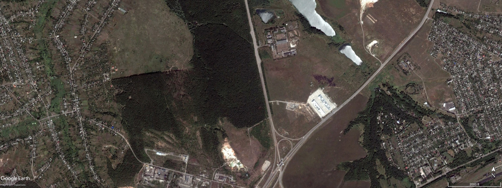
Google Earth’s historical imagery feature allows us to see how military positions on opposing sides have developed around the DFS since the outbreak of the conflict in eastern Ukraine.
In the animation below, likely “DNR” military positions and trenches in the area south of the DFS, can be seen expanding since the beginning of the conflict. In particular, a large trench system can be seen extending to the right of the larger trench circle and position from August 2015 to June 2016. Additionally, note a likely “DNR” checkpoint on the road in the lower left of the image.

On the western side of the H20 highway, west of the positions in the animation above, there is another set of likely “DNR” trenches. Using Google Earth’s historical imagery feature, the development trench can be seen in July 2014, with minimal change to the position since then.

An additional likely “DNR” position (blue box in animation below) is located around a structure between the above area and the DFS.


In this animation, the main trench (green lower box) appears to have initially developed from May to October 2015, with a subsequent northern extension (lower left corner) built between October 2015 and June 2016. Based on the imagery and open source information available, these are likely “DNR” trenches and positions because the dirt piles left from digging out the trenches are on the east side of the trench, indicating that the people in these positions are facing west, towards Ukrainian government-controlled territory.
Opposing Ukrainian Armed Forces (UAF) military positions are likely in the heavily forested area to the west of the DFS (highlighted with the larger orange box in the reference map above). With the satellite imagery available to @DFRLab, it is unclear exactly where in the forested area these positions are, but as seen in the slider above, some likely UAF positions can be seen on the southern edge of the forest near the likely “DNR” positions west of the H20 highway.

Additionally, trenches and military positions can be seen embedded in civilian areas southwest of the DFS. The line of contact goes through the area in the images below, so it is unclear if these positions are UAF or “DNR.” Based on the line of contact shown on MinskMonitor’s LiveUAMap, these are opposing positions; however, the positions are only a few hundred meters from each other, making it more likely that they belong to the same party or are not currently being used and therefore considered no man’s land.


Conclusion
Opposing military positions around the DFS continue to pose potential for a humanitarian emergency. While the international community has called for intervention in this area throughout the conflict in the Donbas, and both the UAF and Russian-led separatist “DNR” forces state they will decrease hostilities in the area, the OSCE SMM continues to regularly observe ceasefire violations in and around the facility.
Follow the latest Minsk II violations via the @DFRLab’s #MinskMonitor.
Also, follow @DFRLab on Twitter for more in-depth analysis from our #DigitalSherlocks.