Changes in the Line of Contact in the Donbas
Territorial changes in the war in easternUkraine
Changes in the Line of Contact in the Donbas
Territorial changes in the war in eastern Ukraine

During the chaos of the war of the pretenders in the so-called Luhansk People’s Republic (LNR), the Ukrainian Armed Forces (UAF) utilized political instability and uncertainty in an attempt to seize more territory, changing the line of contact in eastern Ukraine.
The Ukrainian side of the Joint Centre for Control and Co-ordination (JCCC) called reports of UAF advances “information provocations to discredit the UAF and ATO,” and stated the UAF is in full compliance with the Minsk agreements, as the UAF can “improve” its positions in eastern Ukraine so long as they are in alignment with the line of contact noted within the framework of the Minsk agreements.
https://www.facebook.com/ato.news/posts/1766229460054519
The Press Center of the Ukrainian Anti-Terrorist Operation (ATO) reported the ATO headquarters requested, “people who cooperate with the UAF not distribute any information, photos, and video material related to tactical and operational actions (moving, changing positions, disclosure of units, promotion, etc),” following an incident in which leaked information endangered the safety of UAF troops in the Donbas.
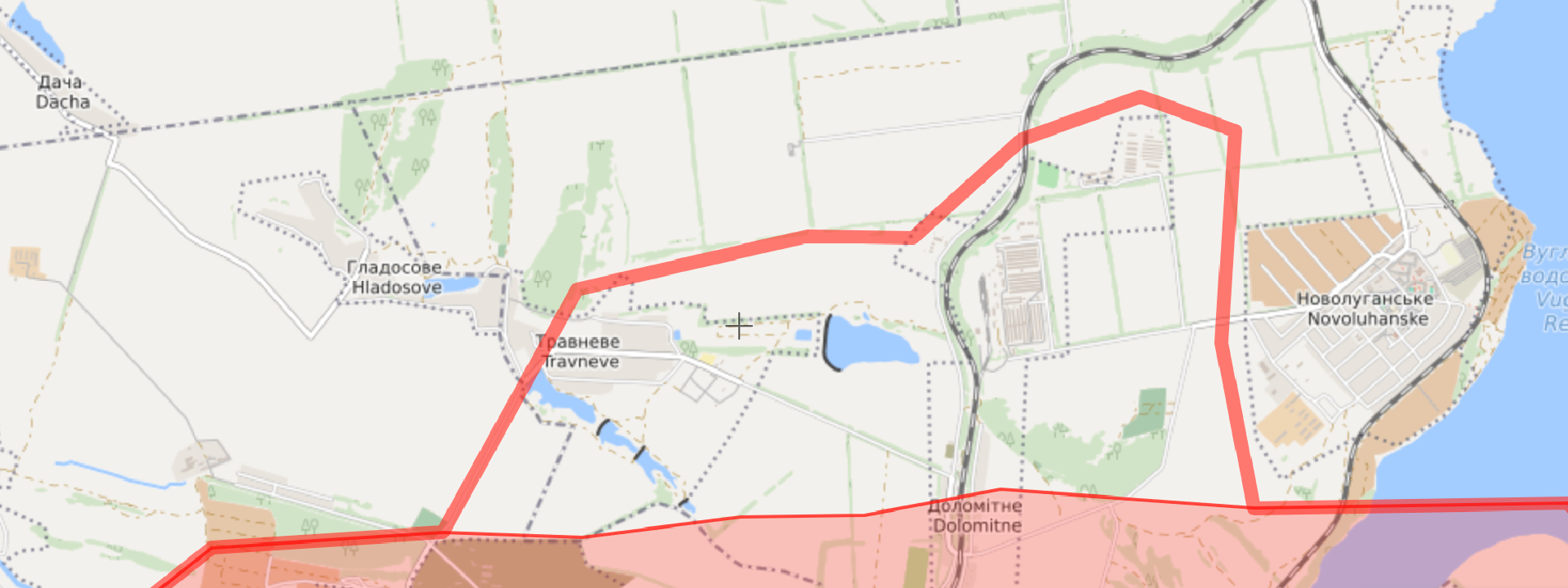
Travneve and Hladosove, Donetsk Oblast
On November 26, the Organization for Security and Co-operation in Europe’s Special Monitoring Mission (OSCE SMM) to Ukraine followed-up on “allegations of the Ukrainian Armed Forces having moved into the village of Travneve,” a village north of Horlivka. Interviews with civilians and members of the UAF, reports from the so-called DNR “press center” as well as social media reports indicate that the UAF 24th Aidar Battalion and 54th Brigade moved into Travneve on November 22. Per the Minsk agreed line of contact, Travneve is designated on the Ukrainian side of the line.

Electricity supply was cut off in Travneve since November 14, and water was cut off since November 21. After UAF seizure, residents were unable to cross the road into non-government-controlled Holmivskyi from November 22–27 to go to their usual grocery store, as Travneve does not have one of its own. Travneve has about 120, mostly elderly, residents. After November 27, the road connecting newly-government-controlled Travneve, Hladosove, and non-government-controlled Holmivskyi, reopened to pedestrians.


Since their first visit on November 26, the OSCE SMM tried repeatedly to re-enter Travneve; however, the paved road into the town was covered in mines (including anti-tank mines) beginning November 28, which prevented the SMM from proceeding due to mandated security restrictions.
In a press briefing on November 30, the Anti-Terrorist Operation (ATO) headquarters reported a so-called DNR UAV flight over Zaitseve, Travneve, and Hladsove.
Humanitarian Aid
After the UAF took control of Travneve and Hladosove, the UAF delivered canned food to the villages and published photos along with a daily report on the situation in the east. The so-called DNR spokesperson announced that the recently seized towns were facing a humanitarian crisis, but curiously stressed that there was a “stable supply of essential goods to the villages” from the “DNR.”


Military Positions
Additionally, the same OSCE SMM daily report stated,
Aerial imagery of the area taken on 13 November revealed a forward observation trench north of the village with the main trench system and revetted vehicle positions a further 1200m to the north.
The report is likely referring to the position in the animation below.

Note, this position (highlighted in blue box below) appears connected to another sizable trench system with vehicle positions slightly northwest of its position (highlighted in magenta box below).

Conclusion
Reports about the UAF seizing towns in the “gray zone” are erroneous, and tend to be in line with Russian-led separatist reports. There is no “gray zone” designated in the Minsk agreements, only the line of contact when the agreement was signed and the current line of contact. These lines of contact vary as there have been extensive and repeated violations to the agreements, notably with the battle of Debaltseve in 2015.
@DFRLab will continue to monitor the situation as there are further developments.
Follow the latest Minsk II violations via the @DFRLab’s #MinskMonitor.
Also, follow @DFRLab on Twitter for more in-depth analysis from our #DigitalSherlocks.