Development on the Doklam Plateau
In the wake of the 2017 standoff and disengagement, China strengthened its defensive stance in the Doklam plateau
Development on the Doklam Plateau
In the wake of the 2017 standoff and disengagement, China strengthened its defensive stance in the Doklam plateau

Since the tense June 2017 standoff between China and India on the Doklam or Donglang (洞朗) plateau, China has taken significant steps to improve its defensive posture and military infrastructure in the region. These developments emerged at a significant pace.
The Doklam plateau is a disputed area between China and Bhutan, India supports the Bhutanese claim, but China currently controls the area. The area is strategically important to India and China as it leads to the Indian Siliguri corridor, often referred to the chicken’s neck, which connects India’s northeastern states to the rest of the country.
In June, Chinese road construction in the area prompted an Indian response on the behalf of Bhutan, attempting to halt the construction. The altercation resulted in a standoff and scuffles between Indian and Chinese troops. After online sources spent most January and February pointing out Chinese buildup in and around Doklam, the Indian Ministry of Defense gave a statement on March 7 that China and India “redeployed” after the summer 2017 disengagement.
Chinese developments on the plateau include a dense network of trenches densely covering areas surrounding the strategic road leading to India. Additionally, China has built helipads, storage sites for vehicles, and new roads, as well as widened existing roads to allow for greater logistical capabilities in the event of open conflict.

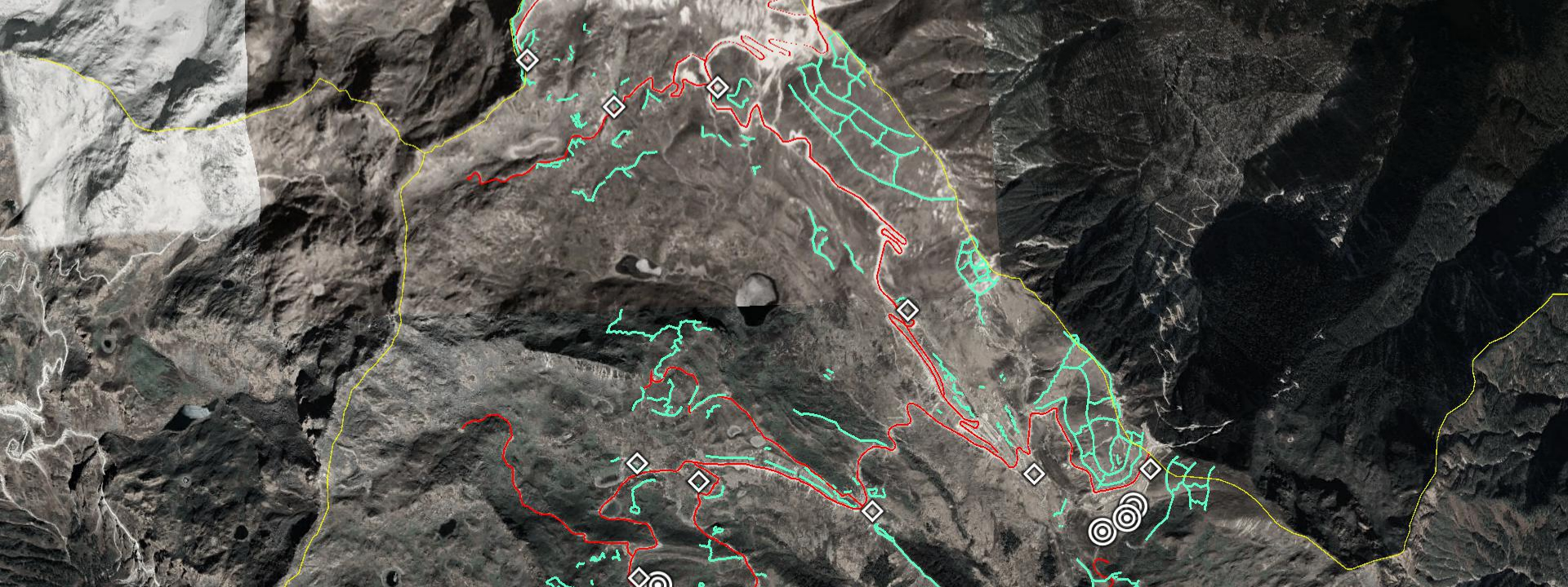
In the satellite image above, light turquoise lines mark new trench lines, while red lines mark new roads and old roads now widened or otherwise improved. White diamonds mark newly constructed vehicle depots and military installations. White circles mark newly constructed helipads. The entire area measures about 3.5 miles (5.6 km) across, and 2.5 miles (4 km) in depth.
The below provides imagery from just prior to the standoff, compared to imagery of recent Chinese development in the region. The slider also depicts some of the improved Indian infrastructure in the area directly adjacent to the Indian border. This includes, but is not limited to, a new paved road leading directly up to the Chinese Donglang border road.
Chinese developments use established roads under their control as a base for branching out with smaller roads and trench systems. This expansion occurred primarily in the western direction towards India, but also southward on strategically important hilltops, deeper into Bhutan. The mountainsides on the de jure Sino-Bhutanese border are covered in the most expansive and systematic trench systems in the area, whereas trench systems closer to the de facto Sino-Indian border are more organic.

@DFRLab extracted four representative satellite imagery samples of recent Chinese development on the plateau, as pointed out on the above graphic. These samples were all on, or directly adjacent to, the main road from China to the Indian border. While some development did take place further from the main road, those alongside it were the most significant.

The above satellite imagery originated from December 9, 2017, at which point most construction had reached its conclusion. Here, three helicopter landing pads have been added in a newly-constructed area for storing military materiel. A protective berm covered the backside of camouflage nets on the storage site in which the northernmost helipad resided.

The second graphic presented a much larger storage area, slightly further down the road, closer to the de facto Sino-Indian border. The site was still under construction in the imagery and trails left behind form temporary camps suggested that troops stationed in the area have moved to more permanent basing.

The third graphic, which was the closest of the samples to the Indian border, depicted an entrenched area for storage as well as a surrounding trench system. The presence of trench systems had nothing to do with their proximity to India, as more expansive trench systems exist further back.

Finally, the newly widened main road leading from China into Doklam is now radically different, and can accommodate better for more, heavier traffic. The road has also been lined with trench systems and various other infrastructure.
Naturally, the strengthening of forward positions did not occur in strategic isolation, but in the context of a bolstered military infrastructure in depth. According to open source research, China has been improving its capacity to accommodate a greater numbers of troops, materiel, and air power to rapidly deploy to the region.
Conclusions
After the summer 2017 standoff in Doklam, China has taken measures to ensure its supremacy in the plateau. These measures include traditional defensive measures such as expansive trench systems and logistical improvements to accommodate for, and sustain, a sudden surge in troop presence. These developments have not only improved the Chinese defensive posture in the area, but also its offensive. China has not been unilateral in developing its military infrastructure in the area, India has maintained trench systems on the de facto border long before, and has constructed a new road leading up to the plateau in the past year.
Follow along for more in-depth analysis from our #DigitalSherlocks.