#PutinAtWar: Russian Bridge After Rushing Waters in Syria
How a Russian bridge connecting Syrian Democratic Forces and Syrian Arab Army territories over Euphrates was recently rebuilt
#PutinAtWar: Russian Bridge After Rushing Waters in Syria
How a Russian bridge connecting Syrian Democratic Forces and Syrian Arab Army territories over Euphrates was recently rebuilt

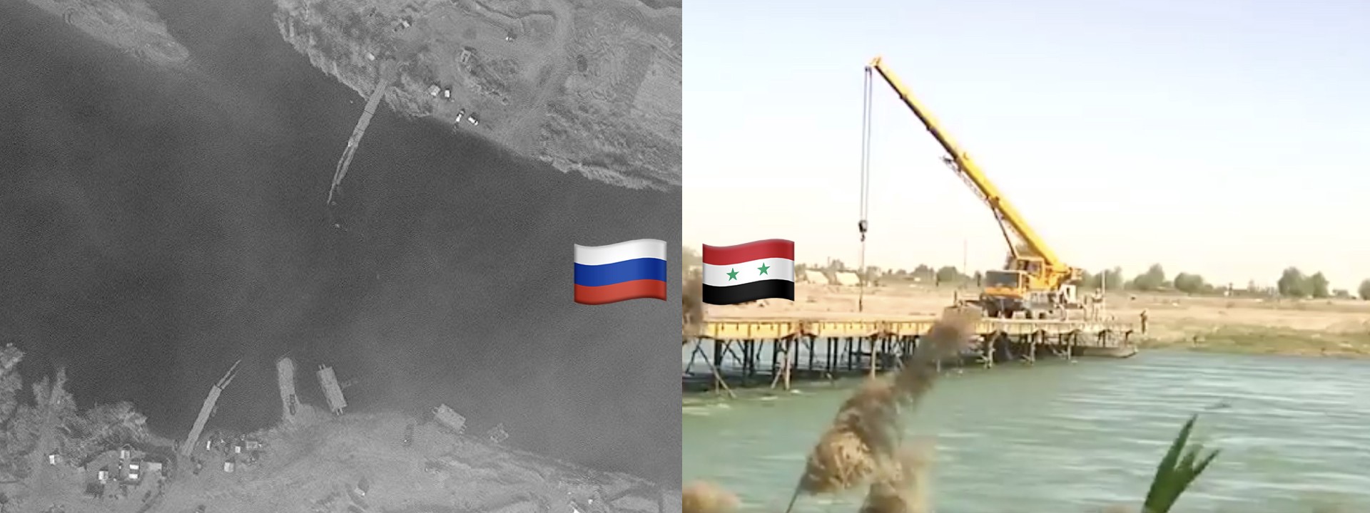
In early 2018, a sudden rise in the water level destroyed a key bridge over the Euphrates River, which separated Assad’s Syrian Arab Army (SAA) from the Syrian Democratic Forces (SDF) in Syria’s east. Soon after the incident, the Russian Ministry of Defence suggested that the bridge might have been destroyed by SDF forces backed by the United States. No clear evidence was collected and no updates were presented by the Russian MoD since February. On April, the Russian MoD released video footage revealing the construction of a new bridge, in the governorate of Deir Ez-Zor (Deir Er-Zur).
@DFRLab took a deeper look into the story of a strategic Russian bridge over the river Euphrates.
On September 2017, construction of a 212-meter bridge was begun by the Russian military in the Deir-Ez-Zor governorate. A week later, the structure was handed over to the Syrian military. It was intended to be used for the transfer of military equipment and personnel to the eastern shore of the Euphrates.
https://www.youtube.com/watch?v=0_EpT9c0kZE
The Russian-built bridge across the Euphrates was destroyed on January 6, 2018 due to sudden rise of water levels in the river, according to RIA Novosti.

The water level and the speed of the current in the river rose sharply at the beginning of January 2018, causing the bridge to collapse. Russian MoD suggested that the SFA could be behind the destruction of the bridge:
“An investigation conducted by Syrian experts showed that the sudden change in the water level and speed was due to the deliberate opening of the floodgates on the Tabqa Dam, which is located in the territory of opposition groups controlled by the international coalition led by the United States. There was no technical need to discharge water. It was done with some other purpose.”
There was no solid evidence proving that the Tabqa Dam was released, but the satellite imagery suggested a sharp increase in water levels. It is likely that the flooding water destroyed the first bridge in January 2018.
New allegations have not surfaced since February, but the Russian military embarked on a new project.
https://www.youtube.com/watch?v=G3gxq_EjL8I
We confirmed the location of the new bridge to be a few hundred meters to the east from the one that was destroyed in January. Landmarks in the video footage closely resembled landmarks captured in satellite imagery.

According to a TASS article published on April 11, Russian servicemen have built a new bridge near the Deir Ez-Zor governorate with a traffic capacity of 3,000 vehicles a day. The new bridge reportedly is 150 meters long and 6.5 meters wide, including a 4.2-meter-wide road, and a 2.3-meter pedestrian zone.

The new bridge connected the western bank of the Euphrates that is controlled by the SAA and the eastern bank, leading into territory controlled by the SDF. With this newly constructed bridge, Assad forces again gained access to the SDF lines, should they decide to launch offensives in the future.

Monthly satellite imagery further confirmed the claims about the new bridge. The old bridge was built in between September and October and destroyed in January. On February satellite imagery the first signs of the new bridge construction were already visible and on April the bridge was fully erected.
Conclusion
After conducting our analysis, we have confirmed that the old Russian bridge was destroyed in January and a new bridge was erected in April. Satellite imagery revealed that the water levels indeed increased between December and January, likely destroying the Russian built bridge. Despite empty Russian accusations towards SFA, it is unclear who were responsible for the flood and no new evidence has been presented since February. Russian persistence over the bridge in Deir Ez-Zor suggests that this bridge bears strategic importance.
This bridge is one of the only transport points over the Euphrates river and can support large numbers of military equipment to be transported in a time of need. This bridge will likely serve as a vantage point for SAA forces in their future attacks on SFA.
@DFRLab will continue to monitor Russian military developments and operation in Syria.
Follow along for more in-depth analysis from our #DigitalSherlocks.