#BreakingSyria: The Battle for the Last ISIS Bastion in Damascus
A quick look into the battle for the last ISIS stronghold in the vicinity of Damascus
#BreakingSyria: The Battle for the Last ISIS Bastion in Damascus
A quick look into the battle for the last ISIS stronghold in the vicinity of Damascus

On May 16, the Syrian Arab Army (SAA) with support from Russia, launched a large-scale assault on a Palestinian refugee camp under the control of the Islamic State. By May 21, the Yarmouk camp was in Assad’s hands. As the regime closed in on the last ISIS-held territory in the Syrian capital, the first video footage from the scene started emerging. @DFRLab analyzed the first open source data to see how the last ISIS held territory near Damascus fell to SAA control.
The Syrian attack and Russian support, primarily targeted the ISIS-held areas inside Hajar Al-Aswad, Yarmouk Camp, and Al-Tadamon. The area, which was home to the largest Palestinian community in Syria, was overrun by al Qaeda-linked fighters and ISIS militants in 2015. Currently it is estimated that the ISIS militants in the area of Yarmouk and adjoining districts had between 1,500 and 2,000 fighters. The first Syrian Arab Army offensive this year began on April 19, and launched a new, larger attack on May 16. This offensive was extensively documented by the attacking Assad forces, providing a glimpse into how the operation unfolded.
On May 16, the SAA posted a video on YouTube, showing the latest military advances in the area.
https://www.youtube.com/watch?v=8jprCbPOsPc
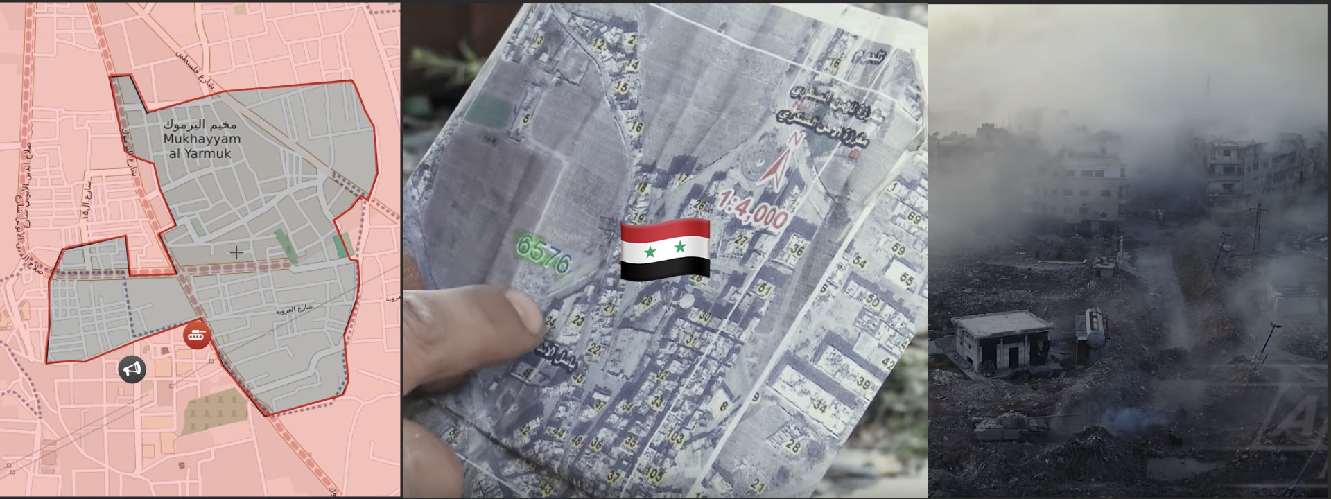
Aerial drone footage in the video captured SAA tanks on the offensive. A soldier holding a map in the video helped to easily geolocate the area to be on the western part of Yarmouk.

Another video that surfaced on the same day provided aerial footage with the Jerusalem Mosque in the background.
S. #Damascus: drone view of battle in N. part of Hajr Aswad engaging T-72s Adra. Mine-clearing blast geolocated (UR-83P has ~350 m range): https://t.co/IrpQYD24nU pic.twitter.com/DD2t4Bvvvf
— Qalaat Al Mudiq (@QalaatAlMudiq) May 13, 2018

The water tower and the unique shape of the mosque helped to identify the location. The tanks in the video appeared to be Syrian modified T-72 tanks — Mahmia, which have seen extensive use with the SAA throughout the conflict. @DFRLab observed three Mahmia tanks operating in the area next to the mosque.

Later that same day, a photo of the Jerusalem Mosque was taken on the ground, allegedly by the SAA soldiers. This photo suggests that the SAA have successfully pushed ISIS past this point.

Here are the two verified locations positioned on a map. These locations were added on the Live Syria Map of May 17, and fit the declared contact line. The pocket controlled by the ISIS militants seemed to be slowly, but steadily shrinking.

Conclusions
The new SAA offensive supported by the Russian forces started on May 16 and ended on May 21 with SAA emerging as victors. According to the Syrian Observatory for Human Rights monitoring group, when the offensive started around 1,000 fighters were present in the Yarmouk area at the time, of which at least 233 were killed in this offensive. Reportedly, a deal with ISIS militants was struck and a significant number of surviving militants were evacuated with busses to Idlib in northern Syria.
As ISIS was pushed out of the area, the government regained full control of the capital and its outskirts for the first time since 2012. @DFRLab will continue to monitor the SAA operations against remaining ISIS forces in Syria.
Follow along for more in-depth analysis from our #DigitalSherlocks.