#BreakingSyria: Syrian Civil War Pushed to Israel’s Border
As Assad’s Syrian Arab Army continues its offensive, rebels positioned artillery next to the Golan Heights
#BreakingSyria: Syrian Civil War Pushed to Israel’s Border
As Assad’s Syrian Arab Army continues its offensive, rebels positioned artillery next to the Golan Heights

As the Syrian Arab Army (SAA) continued to plow through the last rebel defenses, thousands of displaced people were pushed to the 1970 ceasefire line, also known as the Alpha Line, along with rebel groups fighting desperate rearguard battles. Israel, which reportedly supported some of the rebel groups, warned rebels that it would not offer refuge.
On July 16, 2018, a picture was shared online of rebel forces firing artillery less than 50 meters from the Alpha Line. The photo was taken from the Israeli side of the border and showed regime forces within a few miles of the position. @DFRLab analyzed the available open source data to evaluate the state of affairs during the last days of rebel controlled Quneitra and Daraa regions.
The single image of the rebel artillery position adjacent to the Israeli controlled Golan Heights revealed a desperate rebel strategy in the fight agains Asssad’s SAA. This maneuver was likely carried out to provoke the SAA to shoot at Israeli positions. The released image of the rebel artillery position was allegedly taken from the Israeli positions.
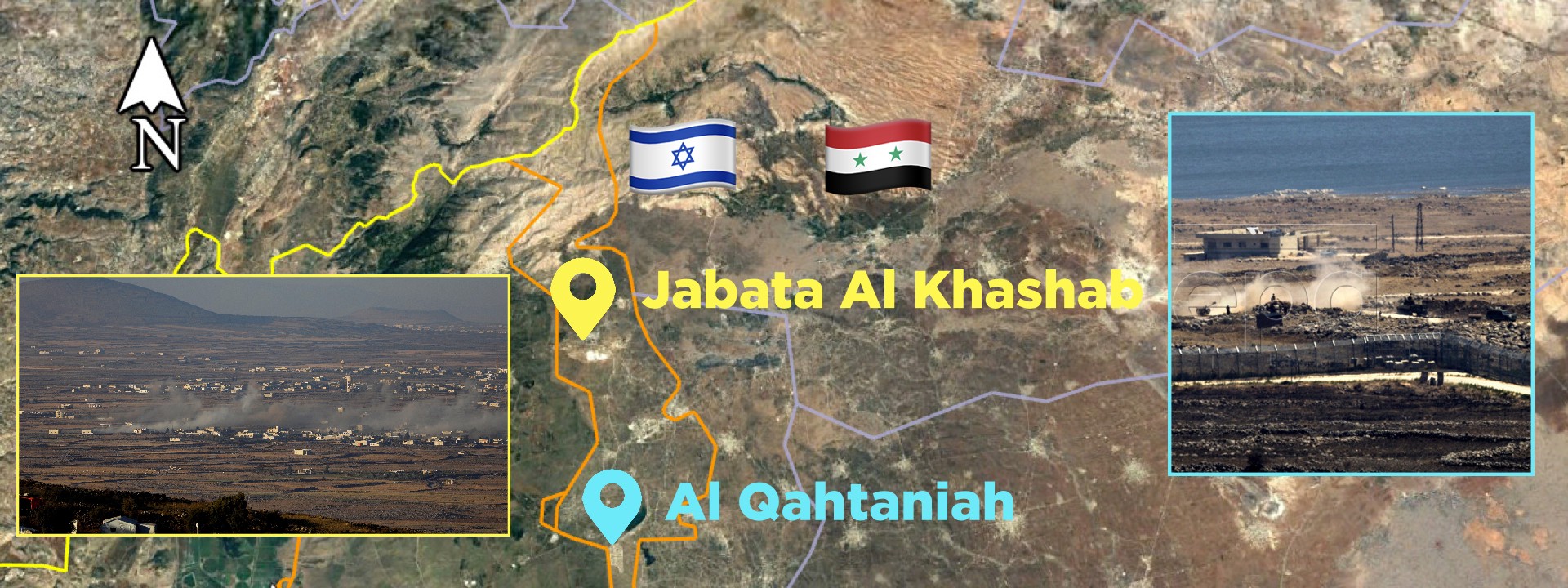
In order to narrow the search, we looked for a large body of water with a nearby two-story buildings visible in the picture. We identified Israel’s barbed wire fence with a distinct bend along the Alpha Line. Each characteristic closely matched a location next to the village of Al Qahtaniah, as noted in the satellite imagery below.

The last publicly available satellite images of the area from Google Maps were taken in May 2015. Since these images were three years old, we cross referenced them with more recent Planet imagery from June 2018. As no significant changes were observed, the higher resolution images of Google Maps were used for geolocation.

Zooming in on the image, we recognized two different pieces of artillery: Russian made self-propelled howitzer 2S1 Gvozdika and a D-30 towed howitzer. Both the 2S1 and D-30 were known to be in possession of the rebels and were used throughout the conflict. Despite the low-resolution image, the weapons were identified due to distinct features.

Another photo surfaced on July 18, allegedly showing the 2S1 Gvozdika being off-loaded from the back of a truck. The Alpha Line barbed wire fence showed that the picture was taken from the Israeli side. The vehicle visible in the background clearly matched the outlines of a 2S1 howitzer. Due to limited geolocation details, the exact location of the photo remains unknown. The photo came from a single online source.

More images representing the current struggle for the control of the region were taken on July 17. A recent article published by Reuters depicted the surrender of the Syrian village of Nawa and reported dozens of missiles were fired on an unidentified, heavily populated city near Quneitra province adjoining the Israeli-occupied Syrian Golan Heights. According to Reuters, the artillery and aerial bombardment occurred hours after thousands of displaced people, who took shelter along the Israeli border, returned to the city that the army had besieged.
An image included in the article showed plumes of smoke rising from the outskirts of the small unidentified town. @DFRLab verified the town to be Jabata Al Khashab, just north of the border with Israel along the Golan Heights. The Anti-Lebanon mountain range is visible in the background, and a small green patch with makeshift buildings constructed by the displaced civilians allowed to narrow the search for the location. The comparison of the three water towers and a mosque visible in the picture, suggested that Jabata Al Khashab was the location.

Reverse image search suggested that these photos were not posted before, rendering them to be likely genuine. Syria LiveUAMap data from July 25, 2018, also supported these claims. Both of the geolocated areas were still in the rebel-controlled area a week after the images were taken.

These territories of Al Qahtaniah and Jabata Al Khashab both fall into the United Nations buffer zone, which was supposed to be protected by a military exclusion zone under the 1974 ceasefire negotiated by the UN that established the current border.

Forces loyal to Assad did not respect these agreements, in part due to the presence of rebel militias, whose actions were not foreseen by the ceasefire treaty. Israeli forces did not act against to the military movement in the buffer zone, suggesting that they were not willing to directly involve themselves in this conflict.
Israeli military officials confirmed Syrian rebel claims that pro-Iran militias operated within 30 kilometers of the Golan Heights border, despite Russia’s promises to Israel to keep the Iranian militia 100 kilometers away from Israeli borders. The constant Iranian militia activities might provoke future IDF responses and a more active role in the Syrian conflict.
Conclusion
By the end of July 2018, Syrian rebels controlled an area only about 10 kilometers wide and 20 kilometers long in the Quneitra and Daraa regions. The fighting is still fierce.
The image that surfaced on July 16 showed the desperate rebel move of firing artillery from the Golan Heights border to provoke a conflict between SAA and the Israeli Defense Forces (IDF). There were no signs that IDF would respond to the fight between the rebels and the SAA in the buffer zone. The close presence of Iranian militias to the Israeli border, continues to be the main possible cause for more active IDF’s involvement in the Syrian conflict.
@DFRLab will continue to monitor Russian military developments and operations in Syria.
Follow along for more in-depth analysis from our #DigitalSherlocks.