#BreakingSyria: Israel Strikes Military Complex Near Masyaf
Strikes hit alleged chemical weapons facility near civilian populated area
#BreakingSyria: Israel Strikes Military Complex Near Masyaf
Strikes hit alleged chemical weapons facility near civilian populated area

On July 21, de facto state news agency SANA loyal to the regime of Bashar al Assad, reported that Israel launched rockets at a military target in northwestern Hama province. According to media outlet, a number of missiles hit an industrial facility near the town of Masyaf but caused only material damage.
The Hezbollah-affiliated Al Mayadeen network reported the alleged targets were scientific research centers for chemical arms production. Meanwhile, The Times of Israel identified the complex as an Iranian-run missile production facility. The Israel Defense Forces (IDF) released no official statements about the event.
@DFRLab looked into the open source data to better understand what happened during this attack.
The event took place on Sunday evening, and photos and videos of the event were posted on social media within hours. Various sources claimed Israel shot seven to ten missiles into Syria, and other sources claimed that at least six missiles hit the actual complex. All photos and videos in this research were checked with Google reverse image search and yielded no positive results, which suggested the content was not posted before and likely accurate.
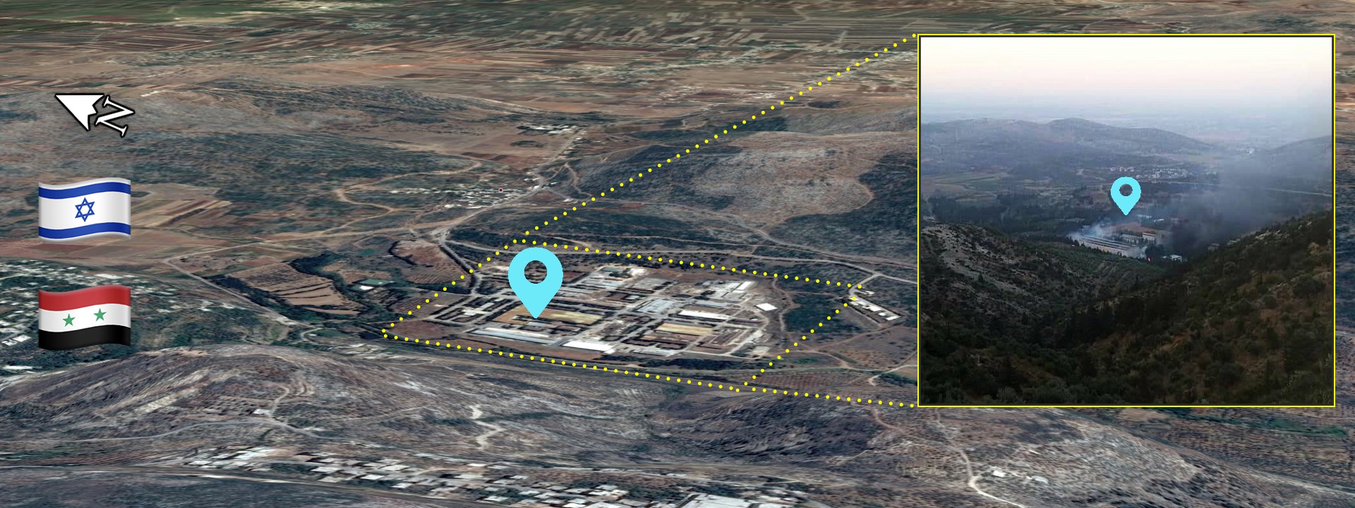
WikiMapia identified the location as a military-related industrial facility, which made for a quick geolocation of the infrastructure to the vicinity of Masyaf. The area surrounding the industrial complex is populated from all sides, the photos and videos that surfaced on social media provided visuals from multiple points of view.
The complex was built in a small valley, surrounded by hills populated with civilians on almost all sides. The distinct silhouettes of the hills helped to verify the location. A large smoke plume visible in the first picture suggested that it was taken moments after impact.

The second picture provided a closer look at the facility from the hills located to the southwest. A smaller smoke plum appeared to rise from one part of the complex.

The third photo provided a zoomed in view from the western side of the complex. One building in the picture was covered in smoke, while the other buildings had no signs of damage.

Using Planet daily satellite imagery, @DFRLab verified the approximate time of the attack. According to our analysis, the structural changes on the base occurred between imagery taken on July 22 and July 23. In the satellite images only one change was visible, suggesting that extensive damage was made only to one of the buildings — a corner of the white roofed building appeared to be destroyed. This was the same building that was covered in smoke in the photo presented before (Geolocation #3).

This finding put in doubt the Syrian media claim of six missiles hitting the complex as the damage seen in the satellite imagery appeared to be limited.
One of the videos posted on social media showed the exact moment of impact of the missile. Due to the low video quality and the lack of geolocation details, this video was not yet fully verified. Nonetheless, the surrounding landscape was similar and captured only one explosion, just as the damage visible in the satellite imagery suggested. Before the explosion a trail of smoke was already rising from the same direction, suggesting that the complex might have been targeted before.
#Pt. Video showing one missile fired by #Israel striking military complex N. of #Masyaf. #Hama – #Syria. https://t.co/8qeZK5ieCS pic.twitter.com/xgv9WUotss
— Qalaat Al Mudiq (@QalaatAlMudiq) July 22, 2018
According to Syrian reports, four Israeli fighter jets took part in the attack, and three missiles were intercepted by Syrian air defenses. A few videos of the alleged interception also surfaced, but due to lack of detail in them, these videos were not verified.
https://www.youtube.com/watch?v=xm14GQIuJMM
The possibility of the missile interception was not far-fetched, as a Syrian air defense base is located only seven kilometers to the west of the complex. Satellite imagery also suggested that the base was equipped with surface-to-air missile (SAM) systems: Russian made S-200 (NATO reporting name SA-5 Gammon) and S-300 (NATO reporting name SA-10 Grumble) SAMs.

Conclusion
In the past weeks, the tense situation in the region led to military clashes between Syria and Israel, the strikes that took place on July 22 was one of the latest examples. The exact details of the attack remain unclear, and the IDF did not claim responsibility or comment. The exact function of the military complex was also contested, with theories ranging from an Iranian-run missile factory to a chemical weapons plant. Nonetheless, the available open source rendered the claim of six missiles hitting the complex highly unlikely as the damage seen in the satellite imagery appeared limited. As the rebel-controlled buffer zone between SAA and IDF is gone, and Iranian militias continue to be active in the region similar attacks can be expected.
@DFRLab will continue to monitor significant military developments and operations in Syria.
Follow along for more in-depth analysis from our #DigitalSherlocks.