#Breaking Syria: Iran Missile Strike in Syria Confirmed
Iran’s Revolutionary Guards released aftermath photos of the September 30 missile strike in Hajin, Syria
#Breaking Syria: Iran Missile Strike in Syria Confirmed
Iran’s Revolutionary Guards released aftermath photos of the September 30 missile strike in Hajin, Syria

The Islamic Revolutionary Guards Corps Aerospace Force (IRGCAF) released photos of targets it annihilated a few days after the missile and drone attacks inside Syria on September 30, 2018.
The Revolutionary Guard fired at least six missiles into Syrian territory, allegedly targeting the terrorists responsible for the deadly attack on a military parade in Ahvaz, Iran. This attack was one of the most overt military operations carried out by Iran in the Syrian conflict.
Iran is a key partner of the regime of Bashar al-Assad, supporting the regime both economically and militarily.
Open source evidence suggested at least one missile malfunctioned after a few minutes of flight, hitting the ground only a few kilometers from the launch site. Iran claimed that the missiles targeted terrorist facilities in Hajin, Syria. Drone imagery released by the Revolutionary Guard was the first public evidence of the missiles successfully reaching Syrian territory.
Confirming The Strikes
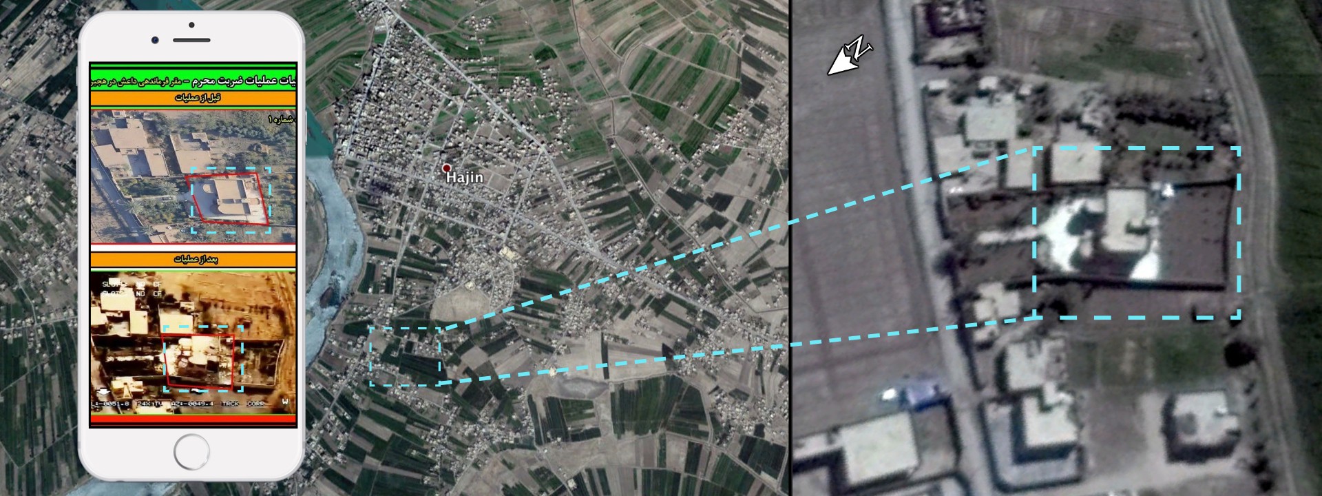
On October 2, 2018 Iranian media outlet Tasnim News Agency shared three sets of new drone imagery, presented as proof of a successful offensive operation. Tasnim News Agency claimed that these images were taken by an Iranian unmanned aerial vehicle (UAV) over the target area during the October 30 missile and drone strike against alleged positions of ISIS terrorists in Syria. Iran described the missile strike as retaliation in response to the terrorist attack on September 22, 2018, allegedly carried-out by ISIS and ethnic Arab separatists from Ahvaz, Iran.
Tasnim News agency reported that six mid-range ballistic missiles were launched at ISIS positions, but only provided images of three targets. The before and after pictures from the attack showed three private residential houses, in what appeared to be a rural area. Some Twitter users and independent analysts suggested the targets were in the Hajin area. @DFRLab verified all three locations by using high resolution satellite imagery and cross-checked it with daily satellite imagery.
The first targeted building featured a very specific shape and a courtyard with light colored tiles. The tiles stood out in the satellite imagery, making the building easy to geolocate.

The comparison of daily satellite imagery confirmed the destruction. September 26 and October 3 satellite images were most clear due to minimal cloud coverage. The building in the October 3 image showed changes to the structure, which suggested the IRGCAF imagery was genuine.

The second destroyed target was geolocated at the end of the same street as the first target, only a few hundred meters apart.

Similar changes to the second target were observed when comparing the daily satellite imagery from the same period of time.

The third target was located in between the first and second targets, only a few hundred meters from either. The intersection visible in the photos served as the primary reference for geolocation.

The daily satellite imagery was not as clear for this building as for the first and second. Only minimal changes were observed in a comparison of the imagery. Nonetheless, the shadows on the building in October 3 image appeared to have changed, suggesting a change in the structure.

All the Iranian targets were less than one kilometer from one another, and all targets were only one kilometer away from the center of the town of Hajin. Here are all three Iranian targets geolocated south of Hajin in southwestern Syria.
The before and after comparison did not show any damage inflicted to the nearby buildings, suggesting that one missile per target was launched. The fact that only three targets were shared added additional doubt if all missiles successfully reached their destinations. As previous @DFRLab research suggested, at least one of the six missiles launched most likely did not reached its target in Hajin area, Syria.
Conclusion
The imagery released by the IRGCAF gave us more information about the October 30 strike on Hajin, Syria. Open source data confirmed with high probability that the October 30 strikes into Syrian territory happened and successfully hit at least three targets, which could not be confirmed at the time of the previous @DFRLab research.
Nonetheless, this information did not allow to determine the actual purpose of these buildings. Currently there is no verifiable information is available on the targets or what people in them were doing to be targeted. It also remains unclear how many of the six launched missiles reached Syria, as only three targets were hit in the Hajin area.
This event marks one of the most public instances of Iranian military activity on Syrian soil. This incident was significant because it was an escalation in Iran’s direct involvement in the Syrian conflict, and it remains unclear whether the action was carried out in coordination with Assad. No active response from Syrian authorities, or Israel, have been reported as of now.
@DFRLab will continue to monitor Iranian military operations and other involvement in the Syrian conflict.
Follow along for more in-depth analysis from our #DigitalSherlocks.