Incendiary Weapons Used in Civilian-Dense Hama Region of Syria
Amid the Syrian Arab Army and Russian military offensive in the Hama region, open-source evidence revealed potential use of incendiary munitions by regime forces
Incendiary Weapons Used in Civilian-Dense Hama Region of Syria
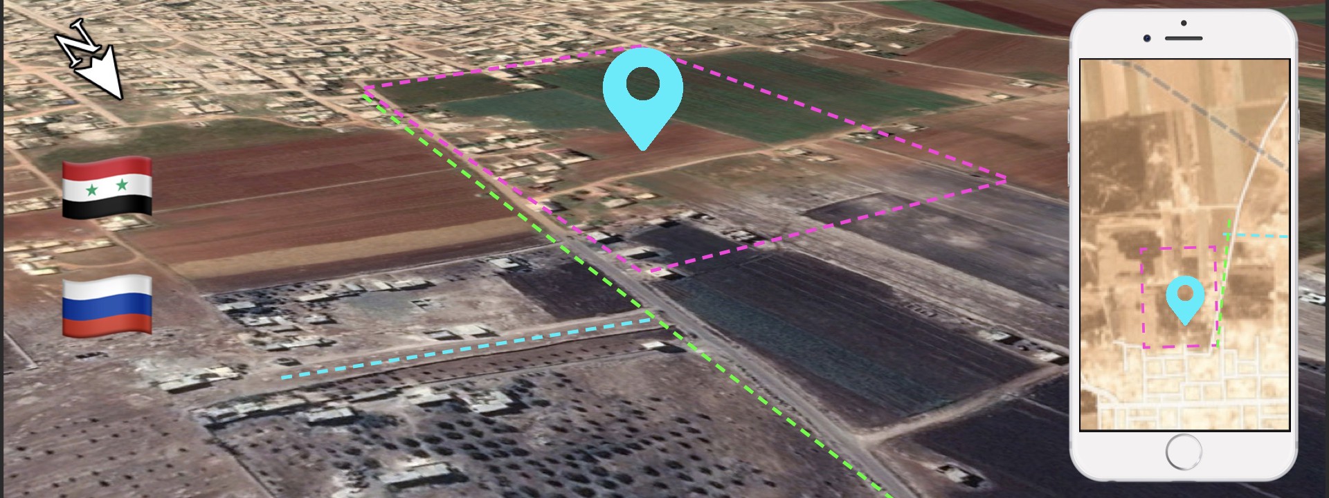
BANNER: (Source: @LAndriukaitis/DFRLab via Google Maps, background; Planet.com, right)
The Syrian Arab Army (SAA), backed by the Russian military, used incendiary munitions to break through rebel lines in the Hama region of Northern Syria, the DFRLab found.
Incendiary munitions are bombs containing flammable chemicals that are designed to start fires that are hard to extinguish. Because of their destructive potential, especially in civilian-populated areas, the international community heavily sanctions their use. Despite the fact that the use of incendiaries is not illegal under the international law, their use is strictly regulated. The United Nations Convention on Certain Conventional Weapons, in particular, restricts the use of incendiaries on civilian areas — their indiscriminate nature makes them hard to aim and increases the possibility of collateral damage.
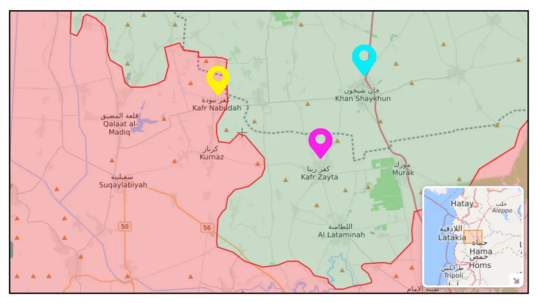
The onslaught spearheaded by the SAA in the Hama region started in late April 2019 and shows no signs of abating. The brunt of the late Spring SAA attacks were concentrated on the area close to the town of Kafr Nabudah and achieved limited gains. On May 26, reports of the regime’s use of incendiary munitions on the premises of Khan Sheikhoun (Khan Shaykhun) and the surrounding areas surfaced in the local media.
The DFRLab investigated the reports using daily satellite imagery and provided open source evidence to prove these claims. Burn marks on the terrain characteristic of incendiary munition use were found not only around Khan Sheikhoun but also near Kafr Zita (Kafr Zayta) and Kafr Nabudah.
The Hama Campaign
The ongoing offensive, started in late April, is considered to be the most intense military clash between SAA and rebels since the summer of 2018; as of now, however, the SAA has achieved only modest gains. The town of Kafr Nabudah has become a symbol of this struggle: having changed hands three times throughout the offensive, it is currently controlled by the SAA. According to the SANA news agency, the fighters holding the front on behalf of the SAA are led by the Hay’et Tahrir al-Sham (HTS), the former al-Qaeda affiliate previously known as the Nusra Front.
The two-month-long offensive has already killed 544 civilians and wounded 2,117, according to the Syrian Network for Human Rights (SNHR). Despite the high civilian toll, relentless attacks by the regime continue. Sources have reported that in addition to bombs and artillery shells, Assad regime forces have also dropped thermobaric, cluster, and napalm bombs. The international community has denounced the use of incendiary munitions, yet Assad’s regime has continued to deploy them throughout the conflict. These munitions are especially deadly in civilian-populated areas, as upon contact they cause fires that are difficult to extinguish.
On May 26, 2019, reports of munitions’ use in the rebel-held town of Khan Sheikhoun surfaced. During the attack, one civilian was reported killed and two children injured. Media reports, nongovernmental organizations, and social media users posted videos allegedly showing proof of the attack on the night of May 25.
#Syria: as if crude bombs weren't enough to set fire to crops and agricultural land, visual confirmation Regime is also using incendiary weapons to burn S. #Idlib countryside (#KhanSheikhoun area). pic.twitter.com/yoQpZMeBuN
— Qalaat Al Mudiq (@QalaatAlMudiq) May 25, 2019
Most of the videos were taken at night, making geolocation difficult, so the DFRLab opted to use satellite imagery to verify if the strikes actually happened. Satellite imagery showed burn marks in the surrounding area appeared in the same period of time as the alleged attack on the town. Furthermore, burn marks were also found near the towns of Kafr Zita and Kafr Nabudah, both of which were close to the front line.
Traces of Incendiary Munitions
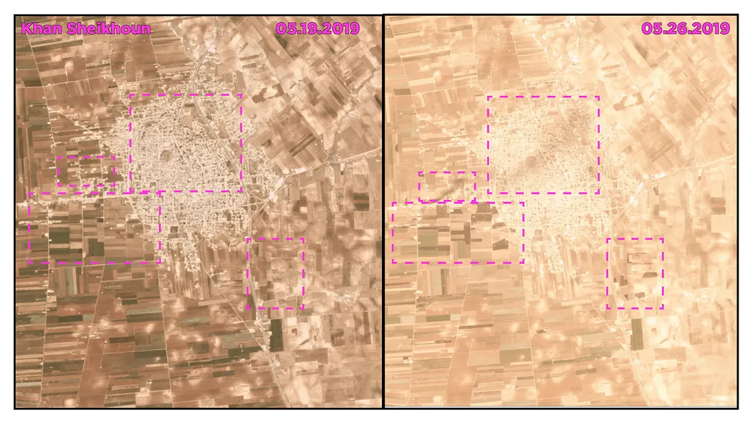
The satellite imagery comparison of the areas near Khan Sheikhoun revealed burn marks in the nearby fields. Furthermore, a streak of potential burn marks appeared in the northern part of the city itself. These findings suggested that the alleged incendiary weapon videos from May 26 were authentic.
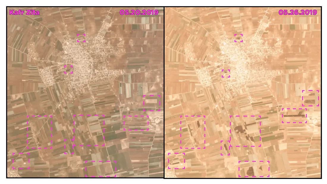
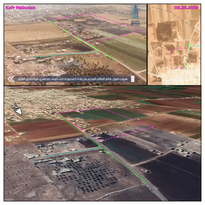
Similar burn marks also appeared in Kafr Zita and Kafr Nabudah, two large towns near the front line. In the case of Kafr Zita, most of the burn marks were concentrated near the southern part of city, with two clear burn marks within the city’s borders.
Lastly, in the case of Kafr Nabudah, the burn marks appeared on the city’s perimeter, yet no clear burn marks were identified within the city limits. Kafr Nabudah is known to have changed hands at least once in the period between May 20 and 26, when rebels pushed the SAA out of the town on May 23.
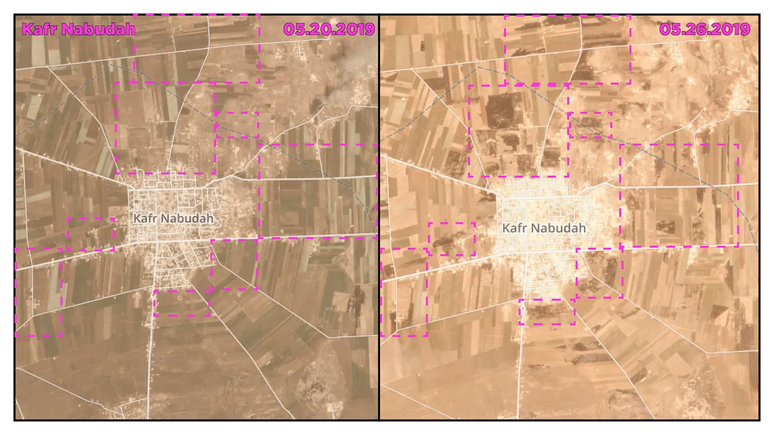
The DFRLab cross-referenced this satellite imagery with the rebel-captured video footage from May 23. In the video, as Assad forces hastily retreat from the town, the same burn marks are visible in the background.
The DFRLab has previously reported on the use of incendiary weapons in the Syrian conflict. In this case, the burn damage near these three towns appeared similar to that examined previously. Satellite imagery alone cannot serve as conclusive proof of the use of such weapons, but cross-referencing the imagery with videos allegedly taken on the ground can provide a higher confidence assessment. In this case, the totality of evidence suggests that incendiaries have been employed in this offensive and raises questions about their further use in the conflict, especially in light of international restrictions on their use.
Follow along for more in-depth analysis from our #DigitalSherlocks.