Holy Tension! Georgia-Azerbaijan Border Dispute Grows
A new road constructed near the disputed David Gareji monastery complex is adding to the problem
Holy Tension! Georgia-Azerbaijan Border Dispute Grows
A new road constructed near the disputed David Gareji monastery complex is adding to the problem

For almost three decades, Georgia and Azerbaijan have worked to advance a robust economic and strategic partnership, especially in the energy sector. An unresolved but low-intensity territorial dispute over an ancient monastery complex, however, occasionally arises and has recently provoked a standoff that risks escalating tensions in the South Caucasus region.
The David Gareji monastery complex, which is comprised of 19 medieval Georgian Orthodox monasteries, is a site of great religious and cultural significance for Georgia; Azerbaijan also has a historical claim to the territory, though, as the complex straddles the unofficial border between the two countries, which runs along a ridge of mountains in the border region. Some of the monasteries in the complex sit on the top of the ridge, putting them in the middle of the dispute. Experts have also assessed it to be a strategic military asset for both countries.
As the latest row over the complex erupted, a Georgian Facebook user posted a photo to his account of what he claimed was a new road constructed by Azerbaijani border troops, built explicitly to block Georgian visitors from entering the site. Another possibly more plausible rationale for the road, instead of blocking visitors, is that it would allow for the militarization of the ridge line, including the monastery complex itself.
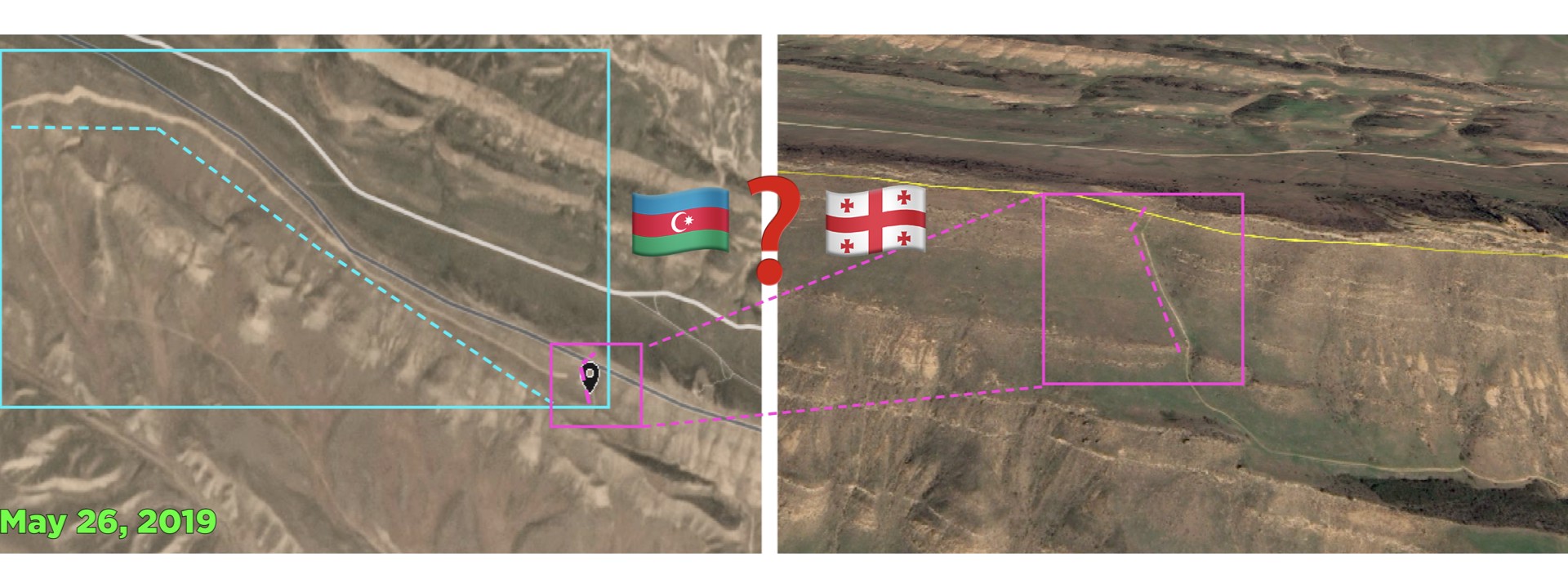
Satellite imagery from late May showed the construction of a new road near Chichkhituri, a monastery within the complex located on the ridgeline roughly two kilometers from the Georgian-controlled portion. The DFRLab verified the images and tracked the progress of the road construction.
Recent Tensions Over the Disputed Monastery Complex
Since its construction in the sixth century, the David Gareji monastery complex has endured several armed invasions, including a devastating attack by the Mongol Army in the 13th century. The present day dispute dates back to the collapse of the Soviet Union in 1991. During the Soviet Union, the territory had been divided between the Soviet Socialist Republics of Georgia and Azerbaijan. In 1991, when Georgia and Azerbaijan gained their independence from the soviet bloc and began discussing border demarcation, the issue of the David Gareji complex emerged as a contested territory. Despite a joint border demarcation committee existing for years, a third of the Georgia-Azerbaijan border, has yet to be delimited, including the parts of the complex that sit on the ill-defined border.
The complex itself remains in dispute, as both countries have been preoccupied by more pressing territorial conflicts — Georgia against Russia in Abkhazia and South Ossetia, and Azerbaijan against Armenia in Nagorno-Karabakh. Baku and Tbilisi have informally agreed to allow access from the Georgian side to the entirety of the territory until the dispute is resolved.

In March 2019, Georgian President Salome Zurabishvili paid a visit to Baku, during which she stressed the need to resolve the border delimitation process. Then, in April, Zurabishvili visited the David Gareji monastery complex. While standing on what Azerbaijan considers its portion of the complex, she again emphasized the need to resolve the dispute as soon as possible.
Several days after Zurabishvili’s visit, Azerbaijani border troops temporarily restricted Georgian clerics’ and visitors’ access to parts of the complex. While they lifted the ban within three days, the situation on the ground has remained tense ever since.
On July 4, a Georgian activist posted a photo of the disputed area on Facebook and claimed that Azerbaijan had constructed a new road to the monastery complex with the intention of blocking Georgians’ access.

Chichkhituri sits on the ridgeline, roughly two kilometers from the Georgian-controlled portion of the territory.

The DFRLab geolocated two of the roads visible in the Georgian Facebook user’s photo: an existing road that predates the uptick in tensions in Spring 2019 and the newly constructed road. Verification of the roads on Planet.com illustrated that the new road was constructed on the Azerbaijan side of the mountains, roughly 0.5 kilometers from Chichkhituri.

To identify the timeframe for the construction of the new road, the DFRLab checked satellite imagery from May 2019, when the latest tensions between Georgia and Azerbaijan flared up. Satellite imagery from May 19 indicated that construction of the road had not yet begun but that, by May 26, it had reached its current shape.

The status of the construction project appears unchanged since May 26, suggesting not further progressed has been made. It remains to be seen for what purpose the road was built or whether the road will now become an additional complication in resolving the border delimitation.
Follow along for more in-depth analysis from our #DigitalSherlocks.