Damage Assessment of the Achinsk Ammunition Depot Explosions
Photos and videos on social media shed some light on the weapons depot explosions in Achinsk, Russia
Damage Assessment of the Achinsk Ammunition Depot Explosions
Photos and videos on social media shed some light on the weapons depot explosions in Achinsk, Russia

A large weapons depot in Achinsk, Russia, suffered a number of explosions in the beginning of August. These explosions inflicted significant damage to the nearby households and also killed and injured a number of people and led thousands to be evacuated.
Russian state media devoted very little coverage to the incident, with brief reporting days after it occurred. According to Kremlin outlet RIA Novosti, one person was killed, 32 injured, and 16,000 evacuated. The explosions in the arms depot reportedly took place on August 5 and August 9. This is not the first incident of its kind in Russia in 2019. On April 28, the Krasmash missile factory in Izhevsk, which produces Russian hypersonic RS-28 “Sarmat” intercontinental ballistic missiles, caught fire. Most of the information about this earlier accident also came primarily from social media users.
On August 8, a separate military incident happened in Russia, this time in the Far North village of Nyonoksa. Initial reports on the same day claimed that at least two people were killed in the deadly incident, with radiation levels in the area drastically increasing. U.S. intelligence and independent researchers subsequently concluded that a failed nuclear-propelled missile launch caused a deadly radiation increase in the area, after which thousands of locals were evacuated. On August 10, an official version of the event was issued by Rosatom nuclear agency admitting the death of five nuclear scientists but saying that the incident was “work related to the engineering and technical support of an isotope power source in a liquid-propulsion system.”
Within hours of the Achinsk incident, photos and videos started surfacing online. The DFRLab used reverse image search to verify that the videos had not been posted before, suggesting they were unique to this incident.
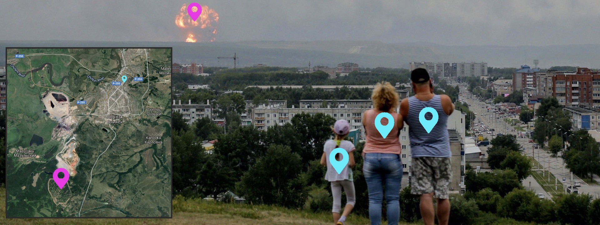
One of the most iconic of the photos was taken on August 5 and featured by a variety of media outlets. The photo shows a family of three standing on a hill in Achinsk, observing a large plume of smoke and fire rising in the distance.
https://twitter.com/AlexKokcharov/status/1160098819973013505
The DFRLab geolocated the photo to verify its authenticity. The geolocation revealed that it was taken in central Achinsk, pointing toward the explosion south of the city. Officials indicated that a lightning strike had caused the explosion, but this could not be confirmed at the moment using open-source information. Historical weather data from WolframAlpha suggests that there were thunderstorms in Achinsk on Monday, August 5, 2019, from 8:00 p.m. until 10:00 p.m., but in the images and photos that surfaced online of the incident, it is still relatively bright outside and no signs of rain are visible.

Videos on social media outlets surfaced as early as August 5 showing large traffic jams in the city of Achinsk as residents evacuated the city.
Evacuation of 5th district of Achinsk is ongoing, people gathering at local mall to be picked up by buses. Emergency alert via loudspeakers https://t.co/ZwAjc0i09X #Russia pic.twitter.com/V7uKUKlgCz
— Liveuamap (@Liveuamap) August 5, 2019
Some of the locals were evacuated by improvised means of transport.
People evacuated, explosion happen, woman anchor scared pic.twitter.com/CxeoYn9Y1T
— Russian Soul (@officialrus1) August 5, 2019
The blast of the August 5 explosion was predicted to be as powerful as 10kT and to highly affect the inhabitants and buildings in a close range.
https://twitter.com/KPHickerson/status/1158462812835811329/photo/1
Some of the surfaced videos showed the actual effect of the shockwave. A nearby factory’s windows began to shake, demonstrating the power of the explosion.
Affect of the shockwave from today’s explosions at the Ammunition depot in Achinsk#Russia pic.twitter.com/h5YisBathT
— CNW (@ConflictsW) August 9, 2019
A variety of photos and videos taken in Achinsk placed the epicenter of the explosion south of the city. A large area in the south was marked as the 60th Combat Engineer Regiment on Wikimapia. After closer inspection of the area using daily satellite imagery, the DFRLab confirmed that the explosions took place there.
To determine the extent of damage from the explosion, the DFRLab compared satellite images from August 4 and August 10. The comparison revealed large areas of burn damage in the fenced military territory. Almost all of the military area appeared to have suffered damage from the explosions, yet due to the lack of clear satellite imagery from the period in between these days it is not possible to determine which explosions were the cause of any of the damage.

Furthermore, a video surfaced on August 8 showing the damage inflicted to the village of Kamenka. The surfaced drone footage has shown only a couple of angles from the area, but at least four households were completely destroyed.
The aftermath of the Achinsk ammunition depot explosion in the village of Kamenka, located a few hundred metres from the ammunition depot. Residents are again being evacuated over fears of more explosions from the ammunition depot#Russia pic.twitter.com/oihXdNhUkK
— CNW (@ConflictsW) August 8, 2019
Cross-comparison of the video with the available satellite imagery confirmed the damage. Clear changes in the inhabited area were visible in the satellite imagery. On August 12, a report surfaced claiming that at least 800 residents of Achinsk and the surrounding area had demanded monetary compensation for the damage inflicted by the explosions.

Follow along for more in-depth analysis from our #DigitalSherlocks.