Early-morning flare-up in Luhansk
The DFRLab analyzed imagery from intense fighting on the morning of February 18,2020
Early-morning flare-up in Luhansk
The DFRLab analyzed imagery from intense fighting on the morning of February 18, 2020

Following an exchange of artillery fire near the Zolote disengagement area in the early morning hours of February 18, the DFRLab found satellite imagery showing the extent of its aftermath. The DFRLab also verified a video showing auto-cannon fire landing in a civilian area as having originated from the Ukrainian side.
Exchanges of fire at this scale are highly unusual at this stage of the conflict, which has stalled over the past few years. It remains to be seen what, if anything, the February 18 exchange means in terms of the larger conflict.
According to the Joint Forces Operation (JFO) — the name for the Ukrainian military operation against Russian-backed separatist forces — the Ukrainian Armed Forces were met with shelling near the areas of Popasna and various villages surrounding the regional flashpoint settlement of Zholobok. The JFO claimed that Russian-backed separatists used 122mm and 152mm artillery as well as 120mm and 82mm mortars in an attempt to break through Ukrainian positions. Artillery over 100mm are banned from being within effective range under the Minsk II agreements.
According to the Telegram channel of Andrey Marochko, former spokesperson for the so-called “Luhansk People’s Republic (LNR) People’s Militia,” the fighting was the result of a Ukrainian reconnaissance group coming under fire and needing to retreat. This was not the first time a Ukrainian reconnaissance group had come under fire in enemy territory, but such instances have not triggered this intensity of an exchange of fire in the recent, more frozen stage of the conflict.
Neither story can be verified through open-source evidence at this point.

In an expression of deep concern around the recent development, the chairman of the Organization for Security and Co-operation in Europe (OSCE), Edi Rama, released a statement calling for restraint.
“This latest incident is not isolated,” said Rama. “Every day the ceasefire is violated, despite the undertakings set out in the Minsk agreements, and the explicit commitment to ‘a full and comprehensive implementation of the ceasefire’ agreed in Paris two months ago. This has a terrible and continuing impact on the civilian population in the affected areas. It is essential that all those concerned ensure the commitment to a full and sustainable ceasefire becomes a reality.”
The severity of the fighting was even visible on satellite imagery. A comparison between Planet Labs imagery from February 18 and 17 showed craters from large artillery barrages east of Zholobok. Normally this type of damage would not be visible in such low-resolution imagery, but the number of impacts and the snow as a backdrop made it highly visible. Most of the impacts appeared to have been on Ukrainian positions.

In a spot report for February 18, the OSCE Special Monitoring Mission (SMM) to Ukraine noted that it recorded 2,300 explosions before noon.
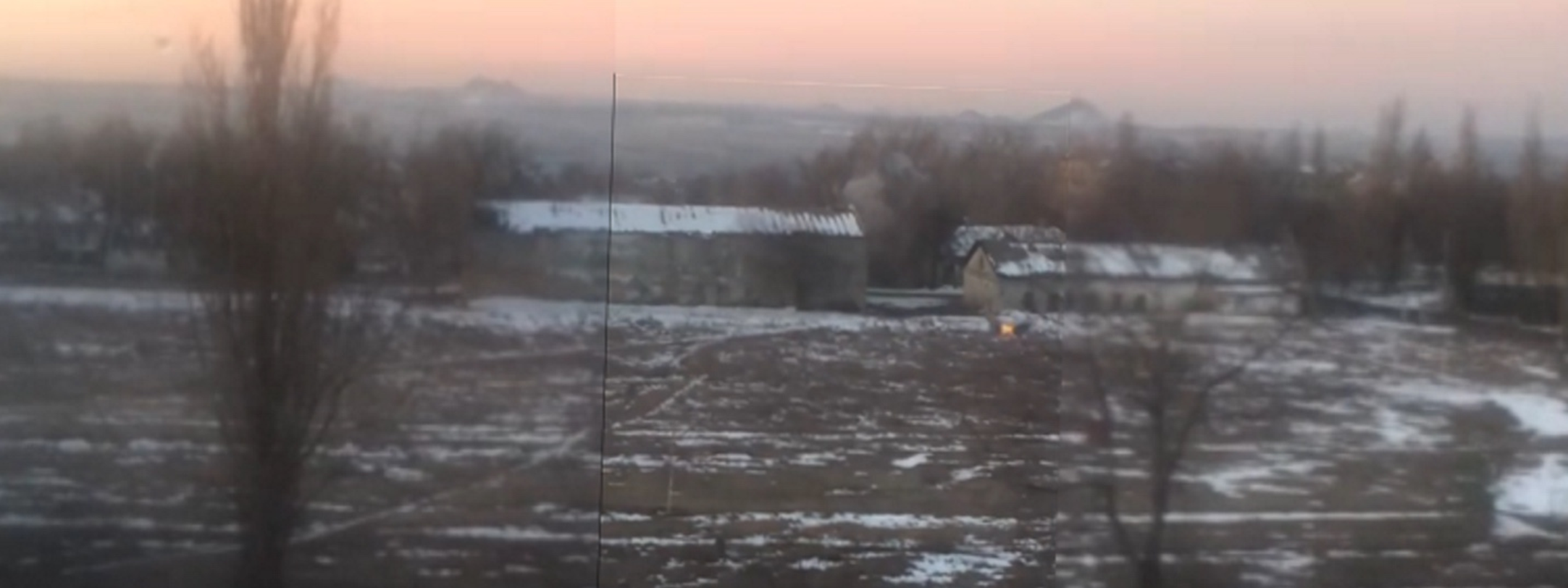
Later in the morning, Marochko posted a video to his Telegram channel which he claimed showed “LNR” forces “responding” to Ukrainian fire. He marked the video as having been from “Kirovsk,” the Russian name for Holubivka. The video showed automatic cannon fire, likely from a BMP-2 infantry fighting vehicle, flying over the cameraman’s building and impacting near other civilian structures. The DFRLab recently reported on shelling in Holubivka.

The video in question appeared to originate from a local VKontakte group dedicated to news from Stakhanov, a larger town close to the location of the fighting. Locals in the chat agreed that the video was shot in “Kirovsk” but used “Kirovsk” as a blanket term for surrounding villages as well. Some users specified that it was shot in the village of Donetskyi, just south of Zholobok.
With this information, the DFRLab geolocated the video as being in the center of Donetskyi, using surrounding buildings as well as slagheaps in the background of the video to verify the location.

The location and orientation of the video suggested that the fire likely came from a Ukrainian position near Zholobok. The village of Zholobok has long been a hotspot in the conflict, and trench lines have grown increasingly close over the years. The DFRLab has extensively covered this area in the past.

Following the direction of tracer fire, it is highly likely that the fire from Ukrainian positions was directed at a mortar emplacement just south of Donetskyi. The distance of the suspected mortar position from the nearest northern Ukrainian position is about 3,500 meters, which would be at the edge of the effective range for a BMP-2 of 4,000 meters. This may explain why the impacts were so much louder than the outgoing shots in the video and also the distinct lack of accuracy, with some shell impacts visible near civilian housing.
Follow along on Twitter for more in-depth analysis from our #DigitalSherlocks.