Storming the sauna: a ceasefire violation in the Donbas
Photos and video of an attack along the line of contact in the Donbas region of Ukraine provided a rare look at ceasefire violations
Storming the sauna: a ceasefire violation in the Donbas
Photos and video of an attack along the line of contact in the Donbas region of Ukraine provided a rare look at ceasefire violations

On February 18, video stills of alleged Russian-backed separatist forces walking around a point called Banya (translation from Russian: “sauna” or “bathhouse”) circulated on Twitter. The point in question has been in the “gray zone,” the area between the established lines of control of the Ukrainian forces and the so-called “Luhansk People’s Republic” (“LNR”) forces. Subsequently released video of the same incident showed the soldiers firing at Ukrainian positions to the north. This represents a violation of the Minsk II agreements on the line of contact between Ukrainian forces and Russian-backed separatist groups. More significantly, it represents a recent effort to secure a section of the “gray zone.”

This video surveillance offers a unique look into a recent example of ceasefire violations in the Donbas. Ceasefire violations are not new to the conflict; but this incident is significant because it occurred under the watchful eye of a Ukrainian-installed camera, and because the location is very close to the Zolote disengagement area, an area that should ostensibly observe fewer ceasefire violations as equipment and armed forces on both sides withdraw from the contact line.
This incident occurred on the same day that Russian-backed separatists and Ukrainian forces exchanged fire 5 kilometers to the east in Donetskyi, Luhansk Oblast, Ukraine.
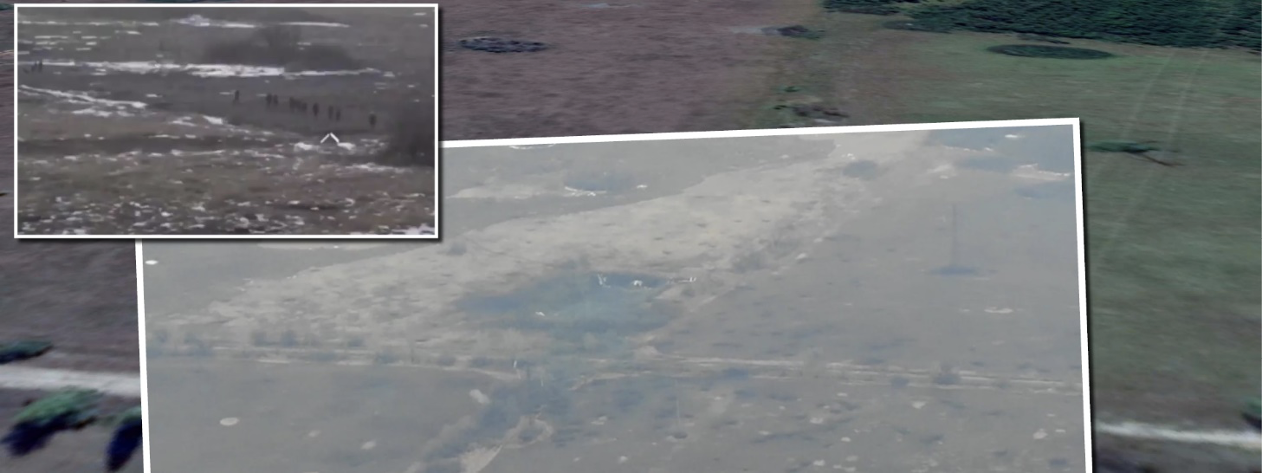
Analyzing the evidence
The video stills were taken from а camera reportedly under the control of Ukrainian forces that had been set up to observe the point itself and the surrounding area. In the photos, soldiers wearing white armbands are clearly shown walking around the point with guns.

On February 27, Telegram user Andriy Tsaplienko posted a video from the same camera, also recorded on February 18, showing as many as 13 armed soldiers approaching the point, opening fire on the point directly before capturing it, and subsequently firing outward at Ukrainian positions retreating from it. There are also several explosions throughout the video hitting the immediate area.
Aerial imagery of the location released by Facebook user Yury Kolesnikov appeared to show a freshly dug trench, but it was unclear when the image was taken. Satellite imagery of the area from weeks prior to the incident was not clear enough to make out details on the ground, but the aerial image appears to show scorched earth, numerous craters, and scattered earth consistent with an explosion — all of which were indicators that Banya was an active military position.

Analysis of the video of the incident in comparison with satellite imagery shows that the forces approached the point from the southwest and fired toward the north and northeast. The Joint Forces Operation (JFO) — the name for the Ukrainian military operation against Russian-backed separatist forces — released a statement about the attack, noting that the “enemy” made an attempt to storm and overtake the observation post but had been repelled by Ukrainian forces.


Point Banya is near the Zolote disengagement area. The surrounding area has several trench positions, marked on the map below in orange, including an “LNR”-controlled position less than 300 meters from point Banya.

Analysis of the terrain suggested that its elevated position overlooking most of the surrounding area, including the settlements of Berezivske, Luhansk Oblast, Ukraine, and Holubivske, Luhansk Oblast, Ukraine, provides a slight advantage. Additionally, the point lies on a road between the town of Holubivske and Zolote, which makes it a strategic monitoring post and access point across the line of contact.
In an interview, Ukrainskaya Pravda, a popular independent Ukrainian outlet founded by Georgian politician Georgiy Gongadze, quoted Andriy Rymaruk, veteran member of the Anti-Terrorist Operation, the predecessor to the JFO, as stating that control of the observation point permitted Ukrainian forces to observe the surrounding area and better determine the origin of incoming fire.

Rymaruk further elaborated, saying that the point had been in the “gray zone” and uncontrolled by any side until January 2020, when Ukrainian forces approached the area to establish an observation point. He claimed that the 93rd and 72nd brigades were in control of the point when, on February 18 at 5:15 a.m., they were fired upon by 120mm mortars. According to him, Ukrainian forces were forced to withdraw from the position and sustained casualties. Ukrainian Defense Minister Andrei Zagorodniuk assured Ukrainians that the position had, nevertheless, been successfully defended and the Russian-backed separatist forces had also been forced to withdraw.
Ceasefire violations along the line of contact are regularly reported by the Organization for Security and Cooperation in Europe’s Special Monitoring Mission to Ukraine (OSCE SMM) through the organization’s daily updates; however, video footage of artillery fire or destruction to property can offer a more detailed look at how these cases unfolded on the ground. This case was unique, as there was clear video evidence of Russian-backed separatist forces advancing on a position with the presumed intention of securing a territorial capture.
Follow along on Twitter for more in-depth analysis from our #DigitalSherlocks.