Front-line positions near Horlivka pose threat to water security in Eastern Ukraine
Fighting near the Siverskyi Donets-Donbas water
Front-line positions near Horlivka pose threat to water security in Eastern Ukraine

Fighting near the Siverskyi Donets-Donbas water pipeline threatens deteriorating water infrastructure in the Donbas
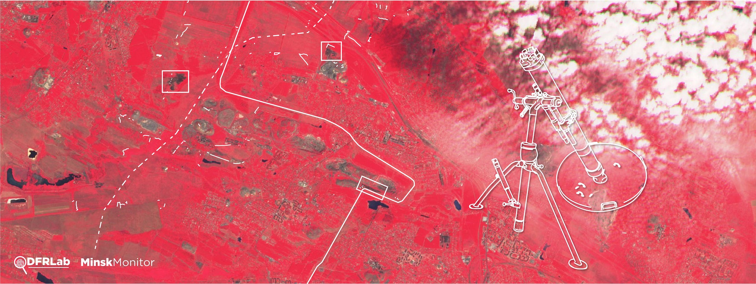
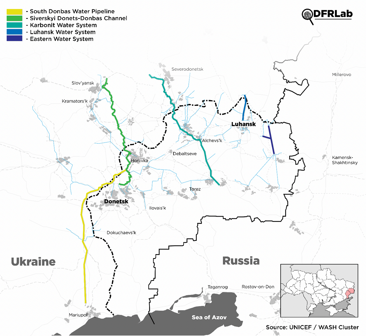
Recent imagery from a section of the front-line near non-government held Horlivka in eastern Ukraine shows how shelling jeopardizes water security for the region. The Siverskyi Donets-Donbas (SDD) water pipeline is a critical part of civilian infrastructure, delivering water to people living in government and non-government-controlled areas of eastern Ukraine.
The SDD pipeline first crosses the front-line in eastern Ukraine as it flows from the Siverskyi Donets river and down into Horlivka, which Russia-backed separatists control. Military entrenchments surround, and at times are directly near, the critical pipeline as it crosses the front-line. The vicinity of these entrenchments pose a danger to the integrity of this pipeline, as artillery and mortar fire directed toward military targets could inflict damage on the pipes.
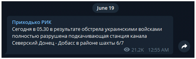
On the morning of June 19, 2020, Ivan Prikhodko, the “Administrative Head” of separatist-held Horlivka, posted to his Telegram channel that Ukrainian armed forces completely destroyed an SDD boosting pumping station near mine shaft 6/7.
The claim appeared to be likely false, as access to water seemed to continue uninterrupted that day, and the story gained no traction outside fringe and separatist-controlled media. The TV channel Union, for example, reported that a water station near Horlivka had been destroyed completely but reused footage from recent reporting in Kominternovo, about 130 kilometers away.
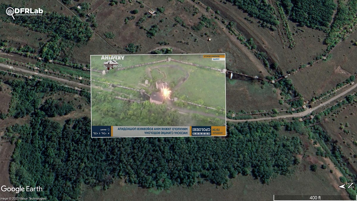
Although reports of the boosting pumping station being completely destroyed appeared incorrect, it was clear that section of the pipeline had suffered damage. On June 22, three days after the incident, Ukrainian television channel Ukraina aired drone footage from this section of the pipeline. The footage showed what appeared to be mortar fire strike a concrete structure connecting the pipes. Trenches belonging to Russian-backed separatists were also visible in the footage, as they connected to the main concrete structure. The extent of the damage was unclear from the footage, but it was likely substantial given that the mortar rounds directly hit the structure.
On June 20, The OSCE Special Monitoring Mission in Ukraine (OSCE SMM) reported shelling being concentrated northwest of Horlivka and in the Avdiivka area for the Donetsk region, but did not mention this specific incident:
The majority of ceasefire violations were recorded in areas north-west of Horlivka (non-government-controlled, 39km north-east of Donetsk) and at east-southerly directions of Avdiivka (government-controlled, 17km north of Donetsk), where about half of the explosions occurred.
Although the OSCE SMM did not take note of this specific incident, other reporting mechanisms in the region did. According to a UNICEF WASH cluster report issued on June 19:
…there was new damage reported to the Siverskyi Donets-Donbas (SDD) channel near the 3rd Lift Pumping Station (LPS) in ‘no man’s land’. Damages is not thought to be significant for the moment, however such damage can worsen due to high pressure…
A few weeks after this incident, on July 6, another section of the pipeline was shelled, this time further into separatist-held territory. Again, military entrenchments were found to be adjacent to the damaged section. Twitter user @rexiro3 managed to geolocate the location of the shelling based on videos taken by locals, and then later by separatist forces.
Горловка, Донецкая область, 2020.07.06 pic.twitter.com/WF8wCwkjlE
— rexiro (@rexiro3) July 6, 2020
The DFRLab was able to confirm the location of this shelling by referencing low-resolution satellite imagery from Planet Labs. The imagery showed a large scorch mark and smoke at the location that @rexiro3 geolocated. Using the low-resolution Planet imagery as an overlay for the high-resolution Google Earth imagery, it was clear that the shelling was directed at a series of four entrenchments designed for armored vehicles. Quite possibly armored vehicles, like self-propelled howitzers or infantry fighting vehicles, prompted the shelling from the Ukrainian side.
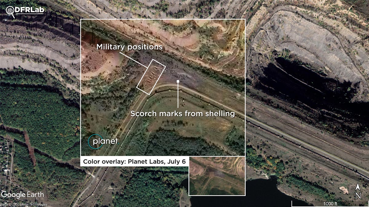
Visible in the footage made public by the Russian-backed separatist forces was damage done to the pipes adjacent to the military positions. Several holes punctured the pipes, causing mild to heavy leaks.
An update by the UNICEF WASH Cluster for July 6 highlighted damage to the pipeline and two small boosting pumping stations, both of which were located in government-held territory, according to the illustration accompanying the report.
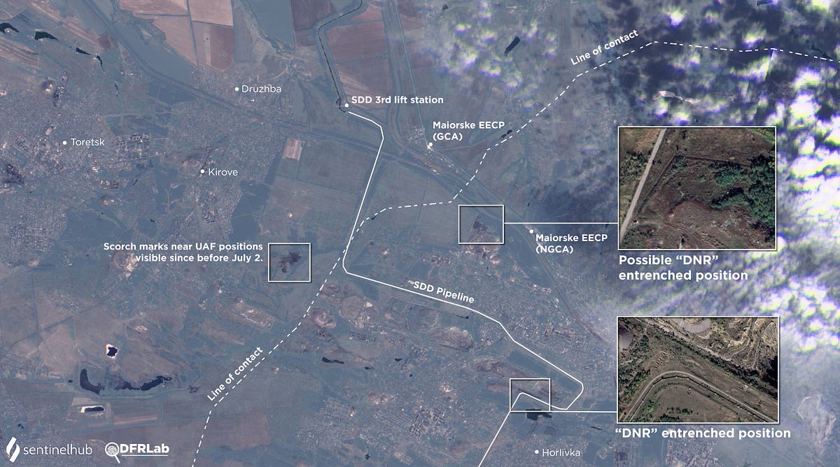
Upon inspecting color-infrared (vegetation) Sentinel-2 L1C satellite imagery for July 7, 2020, two additional large scorch marks were visible. It was not clear if these were created from fighting, but their locations were conspicuous. One of these positions were near the Maiorske entry-exit point in the non-government-controlled area. The scorch mark appeared on July 6 and was located by an irrigation ditch, which may be used by Russian-backed separatists as a forward position. The scorch mark in the government-controlled area appeared sometime between June 28 and July 2 near a series of trenches dug in parallel to power lines.
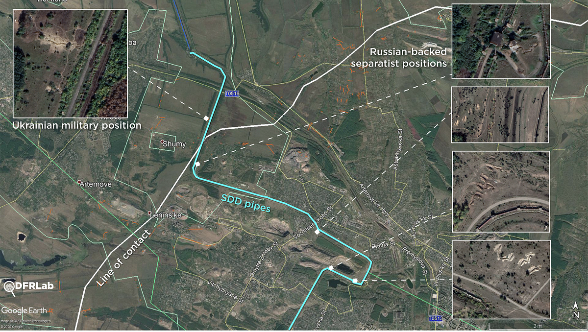
The above imagery shows a collection of fighting positions located immediately next to the SDD pipes as they cross from Ukrainian government-held territory into territory held by Russian-backed separatists. Most of the positions close to the pipeline belong to the armed formations of the so-called Donetsk People’s Republic, but some are also held by Ukrainian government forces.
The security situation in this specific section of the frontline is highly volatile, given the danger that military escalation poses to water security. Granted, in most cases the pipeline can be repaired, but shut-offs still have a negative effect on quality of life for the residents in the region, and the deteriorating water infrastructure is already under significant strain. A new disengagement area in this location, to include the nearby Maiorske entry-exit point, may be prudent to force both sides to abandon frontline positions that endanger SDD pipes. The DFRLab previously reported on a similar situation near the Donetsk Filtration Station, which supplies a large portion of the population in non-government-controlled areas with water. There, fighting between the two sides has put the facility and its personnel at risk on several occasions, causing a series of temporary shutdowns.
Michael Sheldon is a Digital Forensic Research Associate with the DFRLab.
Follow along for more in-depth analysis from our #DigitalSherlocks.