Online videos and satellite imagery show Russian military equipment arrival in Crimea and Voronezh
By Michael Sheldon
In the latter days of March 2021, videos began appearing online showing large amounts of military equipment moving toward the Russian border with Ukraine. The scale of this move is highly significant, with such a concentration of troops near Ukraine not seen since 2014–2015. Contextually, the move was also unusual, since no drills were initially announced that would correspond to it.
Russian troop movements concentrated in occupied Crimea and Voronezh, which lies about 300km north-east of the major Ukrainian city of Kharkiv. These developments come during a tenuous period: a ceasefire in the Donbas has deteriorated completely; the Organization for Security and Co-operation in Europe’s (OSCE) Special Monitoring Mission to Ukraine has just barely had its mandate renewed; and major Russian exercises are planned for September 2021.
Users on Twitter tracked down online videos and mapped Russian military movement from origin to end point. Using satellite imagery, the DFRLab was able to visualize the buildup, as military units from around the country coalesced on training grounds in Crimea and Voronezh.
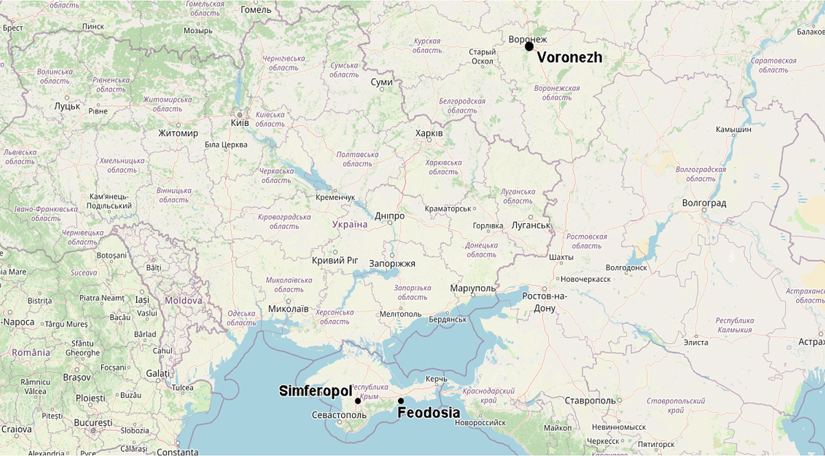
Within the Crimean Peninsula, which Russia illegally annexed from Ukraine in 2014, the two primary destinations appear to be Feodosia and Simferopol.
Feodosia
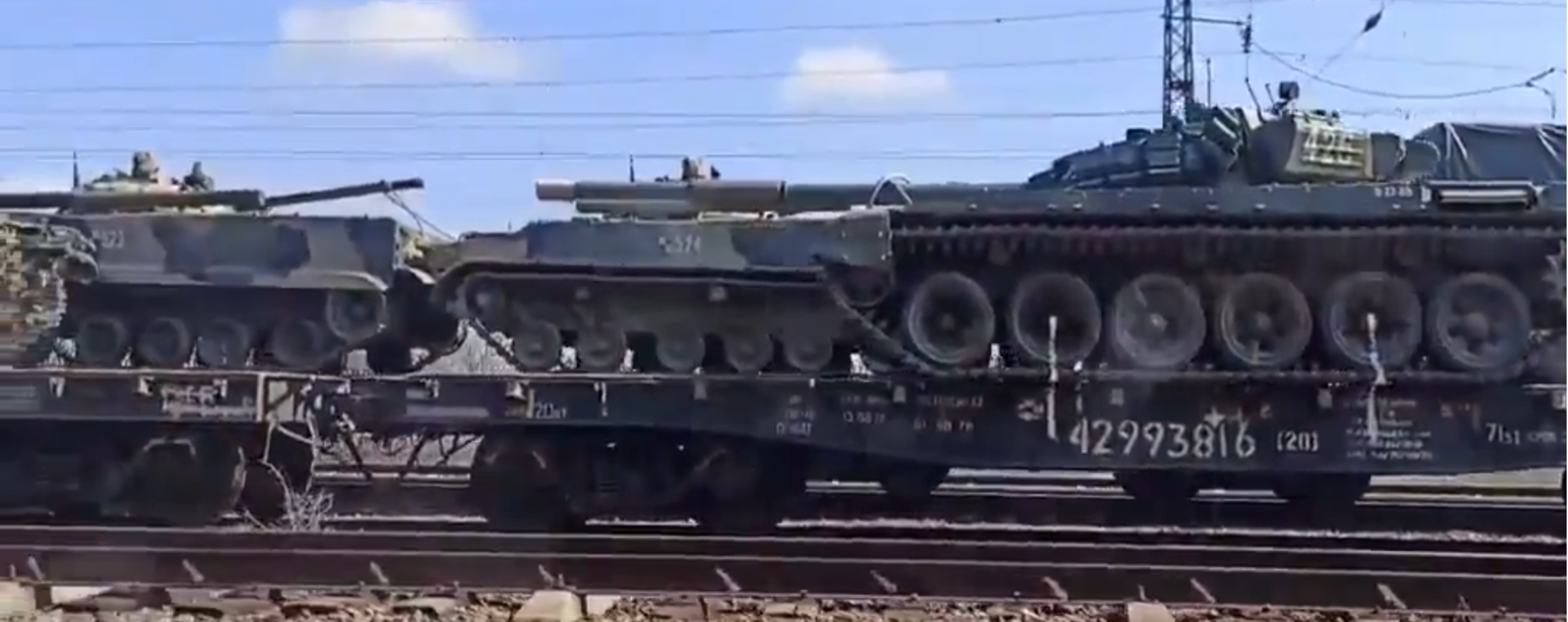
A large amount of military equipment moving into Crimea was destined for Feodosia. Equipment moving by train stopped at the freight station at Aivazovskaya. Several online users pointed this out on Twitter, where they posted results from commercial freight tracking services, showing Aivazovskaya as the end station for many units. For example, Twitter user @galandecZP showed a train full of 2S4 heavy mortars from the 291st Artillery Brigade in Ingushetia.
https://twitter.com/galandecZP/status/1379802488279293954
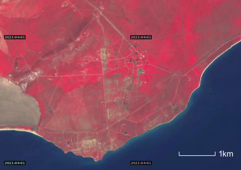
Presumably, the newly arrived troops and military equipment move about 50km east from Aivazovskaya station to the Opuk training grounds. Infrared spectrum imagery from Sentinel Hub allows to visualize vegetation in a bright red/pink color, clearly showing fresh changes at the training grounds.
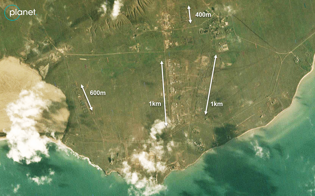
Higher resolution imagery from Planet Labs on January 6, 2021 shows the full extent of the buildup at the Opuk training grounds, with large clusters of tents and military vehicles, some a kilometer in length each. Fresh tire tracks lead from the camp area to the firing area east of the grounds, likely connected with reported exercises in the area.
Simferopol
Aside from Feodosia, Russian units moving into Crimea also go to the peninsula’s capital city of Simferopol. A tweet from CITeam showed how the 76th Airborne Division moved units via rail from Cheryokha, the home of the division’s 104th regiment. Using commercial rail tracking services, they were able to verify the division as the sender, and Simferopol as the destination. The 76th Airborne Division is one of Russia’s most combat-ready units, making its deployment significant.
1/
Long-time Ukraine watchers may remember the Russian 76th Guards Air Assault Division, whose soldiers were killed in Eastern Ukraine in summer 2014.https://t.co/H9KNfI6CnP
Well, they are back — and this time, they are riding a train to Crimea.https://t.co/ocJzHrhhtA pic.twitter.com/4cGpce84fn
— CIT (en) (@CITeam_en) April 5, 2021
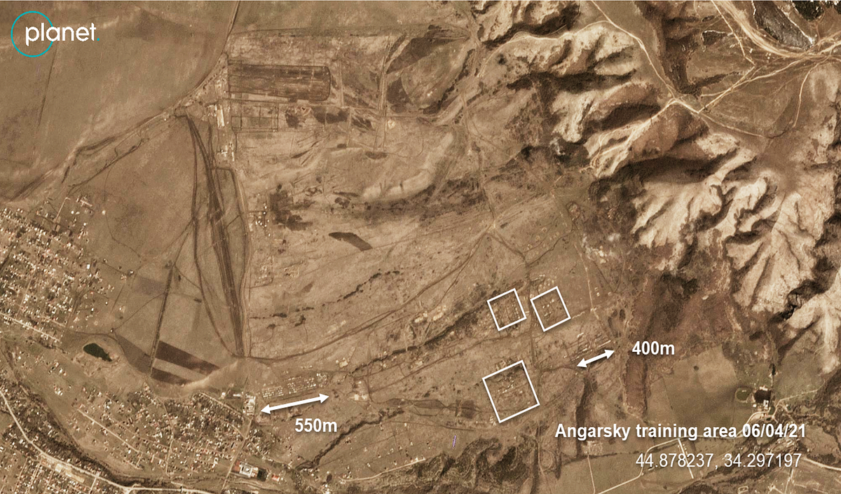
Units arriving in Simferopol appear to go to the nearby Angarsky training grounds to set up camp. This was evidenced both by low-resolution satellite imagery, and open-source videos from the ground.
In one instance, a truck carrying a BMD-4M airborne infantry fighting vehicle collided with an oncoming truck in the narrow streets of the village of Denisovka on the way to this training area.
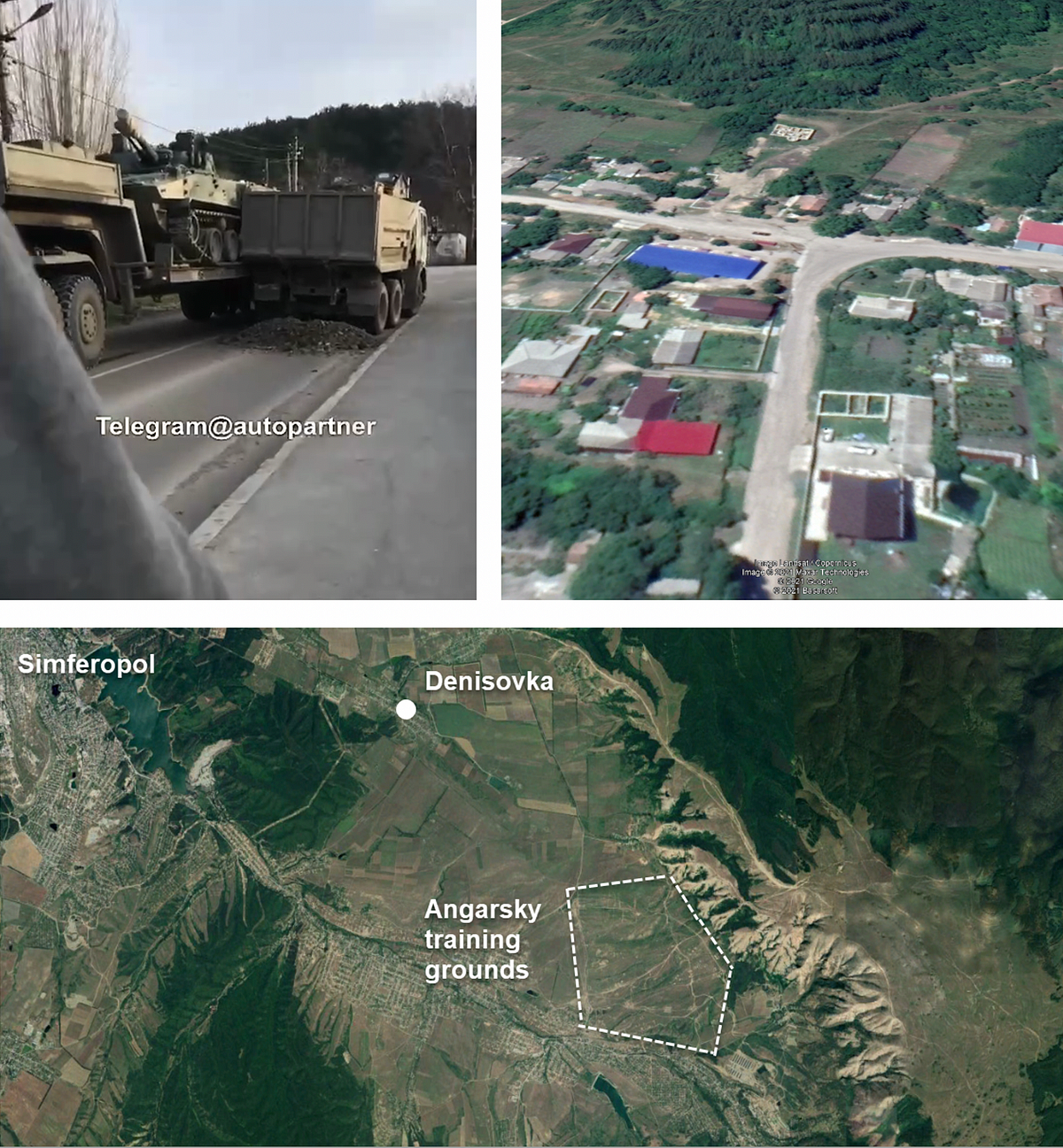
Inspection of updated imagery from Planet Labs shows an increase in activity at the Angarsky training area. While the buildup near Simferopol is not as sizable as that near Feodosia, it is still significant. The image below shows two rows of tents and vehicles about 500 meters long each, along with three smaller clusters.
Voronezh
Lastly, a significant number of troops have converged in Voronezh, settling on the Pogonovo training grounds. Recent imagery from Maxar, acquired by the New York Times’s Christiaan Triebert, shows these camps in high detail.
A new Russian Army camp was set up in the Voronezh region bordering Ukraine, @CITeam_en reports. High-resolution satellite imagery obtained by Visual Investigations indeed reveals hundreds of military vehicles at recently formed staging areas. 🛰️📸: @Maxar https://t.co/GW2p4dcxhy pic.twitter.com/GlW9u9Xb4Q
— Christiaan Triebert (@trbrtc) April 8, 2021
This satellite imagery is again backed up by open-source videos and commercial rail data. A tweet by @galandecZP shows a large amount of logistical vehicles and a Strela-10 short-range air defense system moving by train, destined for Maslovka station, which is just a short drive from the Pogonovo training grounds.
https://twitter.com/galandecZP/status/1379916403185233924
Michael Sheldon is a Research Associate with the Digital Forensic Research Lab.
Cite this case study:
Michael Sheldon, “Tracking the Russian military buildup near Ukraine,” Digital Forensic Research Lab (DFRLab), April 9, 2021, https://medium.com/dfrlab/tracking-the-russian-military-buildup-near-ukraine-d8ab03e853ff.
Follow along on Twitter for more in-depth analysis from our #DigitalSherlocks.