Lie in the Sky
The four ways Russia uses and abuses satellite and aerial imagery
Lie in the Sky
Share this story
BANNER: Russian Ministry of Defence imagery of the M10 hospital presented on October 25th
Open source tools, including satellite photography, have become a vital tool in the effort to expose war crimes, human rights abuses and atrocities. It is therefore no wonder that malignant actors have tried to undermine and subvert these tools, using fakes or misleading interpretations to try and blind investigators.
The Russian government has had a particularly bad record of using inappropriate, misleading and downright falsified imagery since its invasion of Ukraine in 2014. The Russian Ministry of Defence (MoD) has played the leading role in these efforts.
Its misuse of satellite and aerial imagery can be categorised in four different ways:
– misinterpretation
– misidentification
– misdating
– modification
Misinterpreting
On several occasions the Russian MoD has presented imagery and, either through incompetence or malice, misinterpreted what the imagery shows. Frequently this involves claiming a building hasn’t been struck at all because it is still standing, implying the bombing would have resulted in the total destruction of the affected structures. The Russian Ministry of Defence has used this argument to claim that witnesses and evidence of attacks are fake.
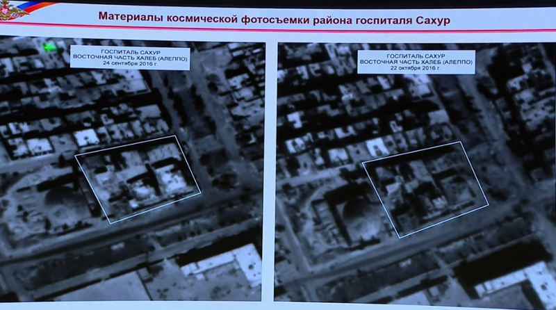
One recent example was the bombing of the M10 hospital in Aleppo on October 1st. In an October 25th briefing, the MoD presented imagery they claimed showed the facility was unchanged before and after the date of the bombing:
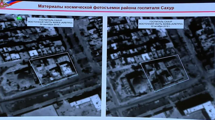
Based on the above imagery, the MoD stated, “This fact proves that all accusations of indiscriminate strikes voiced by some alleged eyewitnesses turn out to be mere fakes.” However, images from the ground confirmed reports from the hospital that it had not only been bombed on October 1st, but also September 28th and October 3rd. Open source investigation uncovered multiple images of the three bombings that hit the hospital, clearly demonstrating that the hospital had been attacked. For example, security camera footage, geolocated to the hospital, shows the moment the October 3rd bombing occurred:
Satellite imagery of the area shows clear damage to the outside of the building, damage the MoD’s satellite analysts were apparently unable to identify with their own imagery:
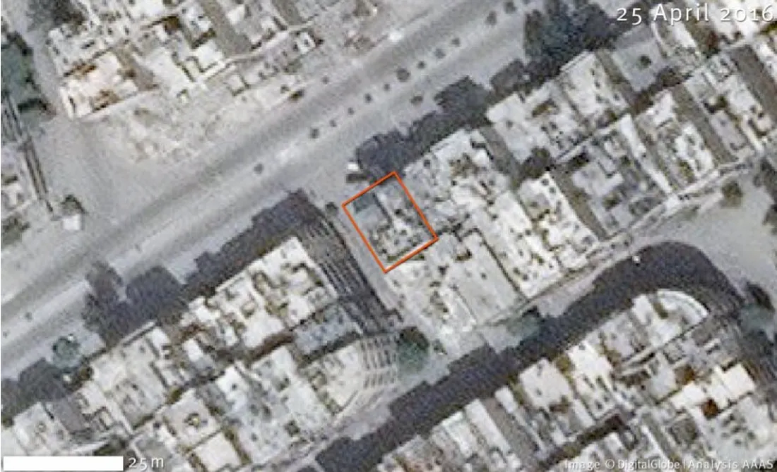
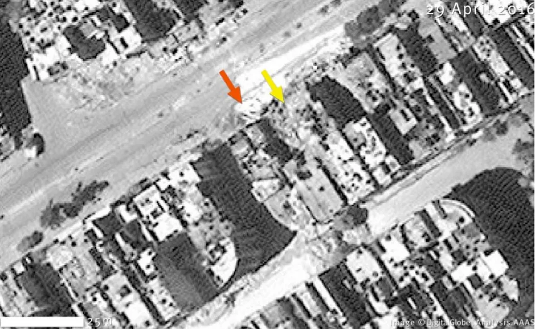
A similar example is the Al Quds hospital bombing in Aleppo on April 28th 2016, where the MoD attempted to claim imagery from after the reported date of the bombing showed the hospital with the same damage as it had in earlier imagery from October 2015:
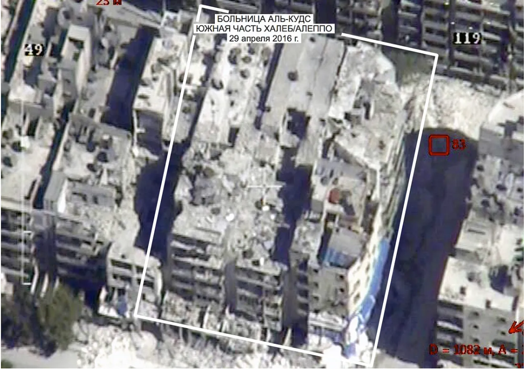
In this case the new damage is in fact visible in the April 2016 image, as documented by sites including Verify Syria:
The American Association for the Advancement of Science also analysed satellite imagery from just before and after the attack stating:
“Analysis of satellite imagery confirmed that Al-Quds Hospital was damaged and an adjacent building had collapsed between 25 April 2016 and 29 April 2016.”
Yet again, another example of the Russian MoD’s interpretation of satellite imagery varying wildly from the evidence from the ground and independent analyses of satellite imagery. Most recently this misinterpretation of aerial imagery was used in the Russian MoD’s denials relating to the bombing of a Syrian school in Hass, Idlib, as documented by the Conflict Intelligence Team, establishing this type of misuse of satellite and aerial imagery as a firm favourite of the Russian MoD.
Misidentifying
The Russian MoD has also made a habit of misidentifying targets and locations. The most extensive example of this came with the commencement of Russia’s bombing campaign in Syria in September 2015. Shortly after the bombing began, the MoD began to post videos from its aircraft showing airstrikes across Syria. Frequently these targets were described as being in specific locations and striking ISIS targets, but analysis of these videos showed otherwise. By examining Google Earth satellite imagery of Syria it was possible to find many of the locations featured in the Russian Ministry of Defence’s bombing videos, and by comparing those locations to the Russian Ministry of Defence’s own map of ISIS controlled areas it was possible to establish that from the first 30 videos claimed to be ISIS targets only one was in ISIS controlled territory as per the Russian Ministry of Defence’s own map.
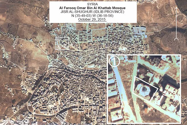
In other videos from the Russian Ministry of Defence grain silos and water treatment facilities were described as oil related infrastructure, part of Russia’s campaign to cut off ISIS’ oil revenues. In response to accusations they had bombed a mosque in Jisr al-Shughur on October 1st 2015 the Russian MoD presented aerial imagery of what they claimed to be the mosque in question, but was in fact an entirely different mosque that no-one had claimed was bombed. When they presented their imagery they even went as far as placing the label for the image over the mosque that was bombed.
In response to reports on their inaccurate descriptions of locations and targets the Russian Ministry of Defence’s response was at first to become far vaguer about the targets they were striking in videos, and to eventually dramatically reduce the numbers of airstrike videos it was publishing. Simply telling the truth seemed not to be an option.
Misdating
Time itself comes under question when the Russian MoD starts producing aerial and satellite imagery. From Syria we have the example of Sarmin Hospital, damaged in an October 20th 2015 airstrike, but which the Russian Ministry of Defence claimed was undamaged, producing aerial imagery supposedly taken after the attack to prove their case:
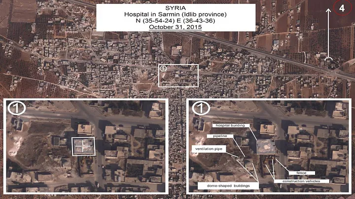
However, careful analysis of videos and satellite imagery showed structures destroyed in the airstrike were still visible in the Russian Ministry of Defence aerial imagery, which could only be the case if the image was taken before the airstrikes occurred, not afterwards as the Russian Ministry of Defence claimed.
In the most egregious example of the Russian MoD lying about the date of aerial and satellite imagery, the MoD presented satellite imagery at their July 21st 2014 press conference on the downing of flight MH17 over Eastern Ukraine a few days only. At this press conference, they presented imagery they claimed showed a Ukrainian air defence base on July 14th and July 17th 2014. This was used to demonstrate how a Buk missile launcher seen at the base on July 14th had left the base on July 17th, shortly before Flight MH17 was shot down.
By examining imagery on Google Earth of the same location during July 2014 it was possible to show the Russian MoD imagery was wrongly dated. In the top left corner of the July 14th 2014 image presented by the Russian Ministry of Defence a large area of vegetation with a path cut through it is clearly visible. In all July imagery of the same location on Google Earth the vegetation is clearly missing, showing the images presented by the Russian Ministry of Defence could not have been taken during July:
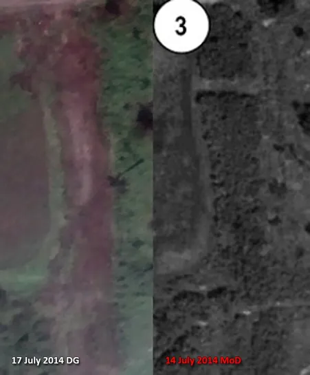
Other details in the image further confirmed the Russian Ministry of Defence imagery was incorrectly dated, allowing the imagery to be dated to a period between late May and mid-June 2014.
Further analysis of the imagery would find even more alarming evidence of the MoD misusing aerial and satellite imagery, going beyond simply lying about the date.
Modifying
Other imagery presented by the Russian Ministry of Defence during their July 21st 2014 MH17 press conference included images which they claimed showed two Buk missile launchers in a field close to the town of Zaroshchens’ke. Open source investigation of this proposed launch site would find that the site was in fact under Russian backed separatist control at the time, with locals denying any sign of Buk missile launchers in the area on July 17th 2014. In the Dutch led criminal investigations team’s September 28th 2016 report, investigators played a conversation between Russian backed separatists who were expressing their surprise the area was claimed to be the launch site, as it was under their control at the time.
Considering this evidence that there were no Buks in the field at the time, how could the Russian MoD have a satellite image showing that there were? The answer was shockingly simple; the Russian Ministry of Defence had presented altered satellite imagery. Initial analysis by Bellingcat, followed up by analysis by experts at the Middlebury Institute of International Studies at Monterey using the Tungstene forensic imagery analysis software, showed the Buk missile launchers had been added to the image, stating that the image had “been so heavily manipulated that it lacks any credibility as evidence”. Local residents didn’t see the missile launchers because they had never been there in the first place, only existing in the Russian MoD’s faked images.
These are some of the many examples of the Russian MoD’s misuse and abuse of satellite and aerial imagery. It would show incredibly poor judgement to accept any of that imagery and the Russian MoD’s opinions on it without further, independent, analysis. Fortunately for those of us trying to separate fact from fiction in conflict zones, open source material has provided us with a wealth of information to do that type of independent analysis, something the Russian Ministry of Defence may one day come to realise.