Saudi-led Coalition Drone Downed in Yemen
Houthi forces down a coalition-piloted drone in the fields of Sadaa in Yemen
Saudi-led Coalition Drone Downed in Yemen
BANNER: (Source: @LAndriukaitis/DFRLab via GoogleMaps, background; News of Yemen/archive, left)
Houthi forces downed a China-made coalition combat drone over the Saada region of Yemen on or around April 19, 2019, when Houthi-affiliated media outlets first reported on the incident.
Judging by the video, Houthi forces used a surface-to-air missile to take it out of the sky, demonstrating that the Houthi forces, despite their technological inferiority to the coalition forces, are able to put up a fight against more advanced weaponry.
Photos and videos that appeared on social media provided open source data on the incident, showing both the moment when the unmanned combat aerial vehicle (the “drone”) was hit and after it had crashed. Most of the media outlets reporting on the incident agreed on the location of the crash and that the drone most likely belonged to the Saudi-led coalition of Arab military forces fighting the Houthis, but they did not confirm the model of the downed drone.
Photos, videos, and other open-source information found on social media outlets allowed the DFRLab both to confirm the location of crash site and to identify the model of the drone, assessed to be a Chinese Wing Loong I.
The Crash
On April 19, Houthi forces took out the drone in question using a surface-to-air missile. The model of the missile, however, was debated. The Houthi-affiliated al-Masirah media outlet reported that the downed drone was “a U.S. spy drone, run by the U.S.-Saudi aggression” — likely referring to the United States-made General Atomics MQ-1 Predator — and also confirmed the Saada region as the crash location.
Meanwhile, the Iranian state-affiliated Press TV reported that Houthi forces had downed a Chinese-built “[drone] belonging to the Saudi-led military coalition.” Press TV likely believed the downed aircraft to be either a China-made CAIG Wing Loong I or Wing Loong II.
It is also not exactly clear which country’s drone was shot down, as both Saudi Arabia and the United Arab Emirates fight in the coalition and have the Wing Loong I model in their airfleet. The first photos and videos started appearing on social media and media outlets on April 19.
Geolocating the Crash Site
Most of the media articles and social media posts identified the Saada region as the likely drone crash site, which the DFRLab verified via geolocation.
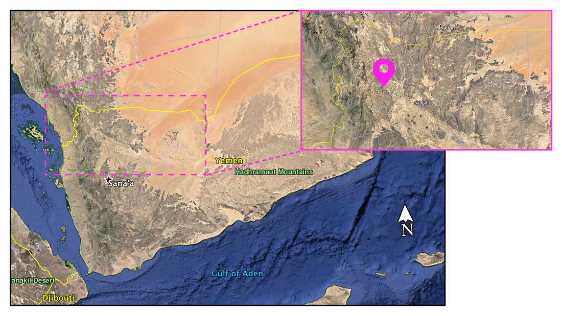
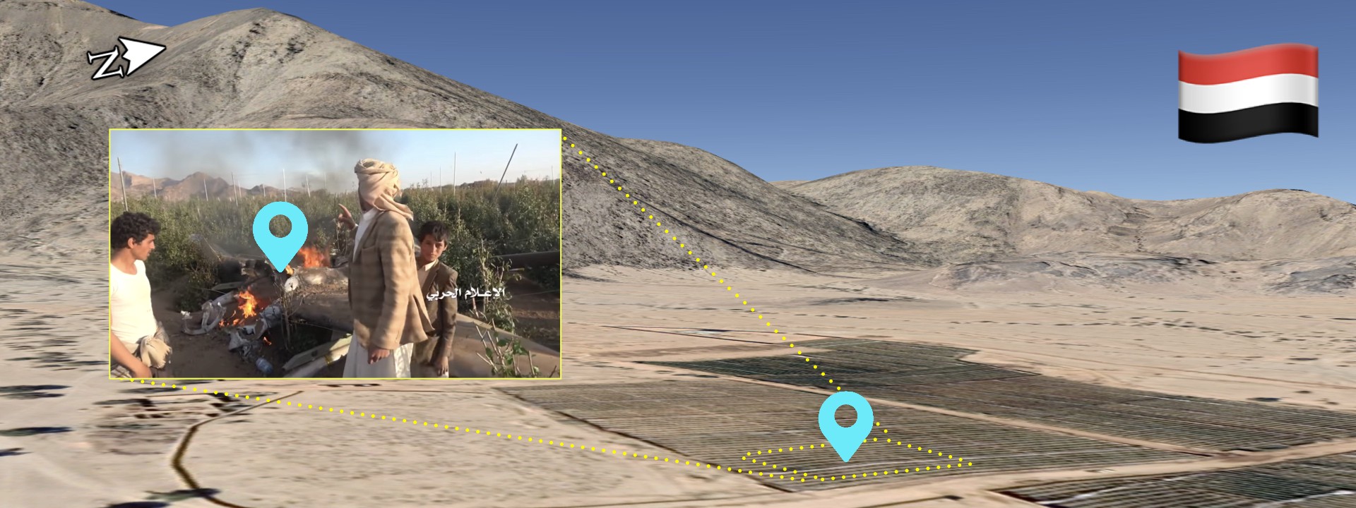
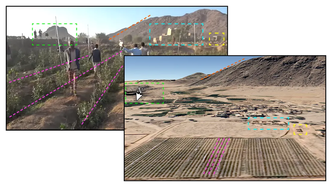
The News of Yemen published the most useful video on April 20 on its official YouTube channel. The video provided images from both the moment the drone was shot down and the crash site.
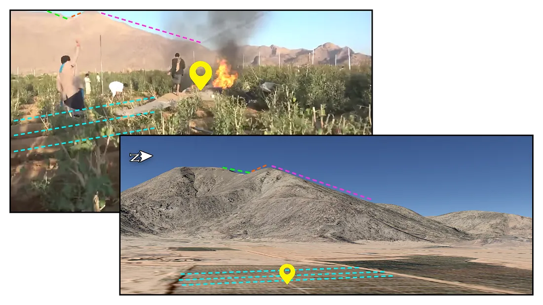
The most notable feature in the video for geolocation purposes was a mountain range in the background. The drone landed in the middle of an agricultural field, which was surrounded by a mountain range on one side and flat land on the other. The Google Maps 3D terrain images further confirmed the exact location of the crashed drone.
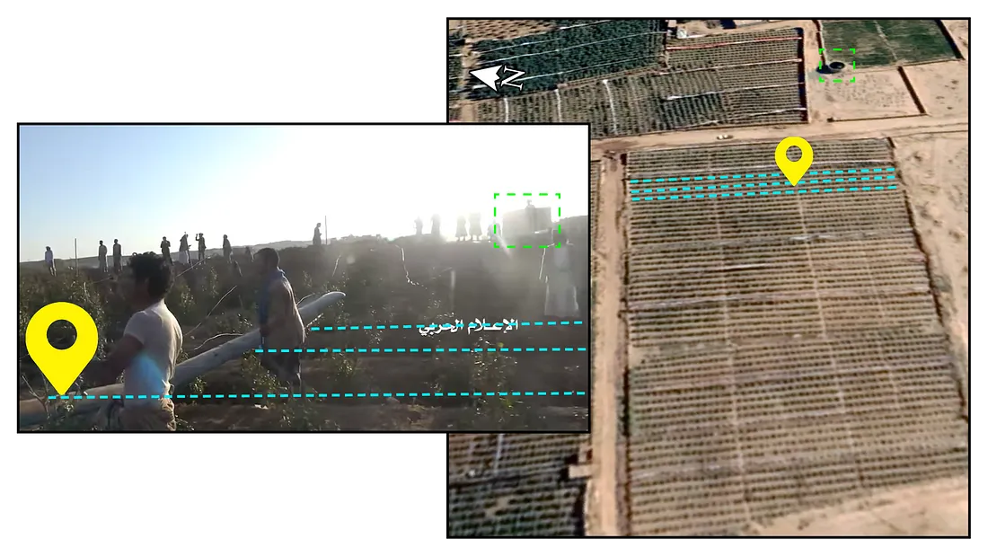
On the other side of the field, a small building, with low stone walls adjacent to it, was visible, futher confirming the location.
In a third still from the video, on the southern part of the field, a distinctive rock formation also stood out.
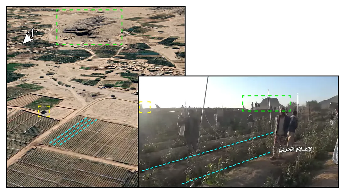
Close to the rock formation another mountain range was visible, as well as several buildings, further confirming the location.
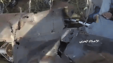
Soon after the crash, while the UCAV was still in flames, locals gathered and disassembled the drone for parts. Some of the scraps of the crashed drone were taken by local children as well.
Identifying the Model
After geolocating the images from the crash site, the DFRLab compared the drone remains found at the crash site to identify the model shot down, focusing in particular on the models mentioned in the various news reports on the incident: the United States-made General Atomics MQ-1 Predator and the China-made CAIG Wing Loong I and II. The drone in question most closely resembled the Chinese Wing Loong I.
The three-bladed back propeller, side wings, and the lights on the tip of the wings clearly matched images of the China-made drone, though it might be a variation adapted specifically for the buyer.
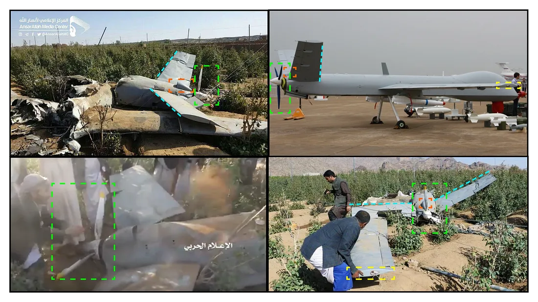
The video also revealed that the drone was outfitted with air-to-surface weaponry, which appeared to be a China-manufactured Blue Arrow 7 missile. The Blue Arrow 7 is the weapon most commonly fitted on Wing Loong I and II drones.
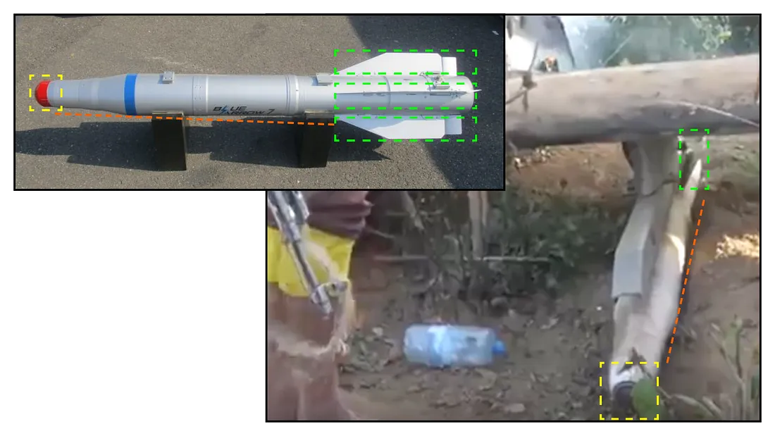
The presence of a Chinese missile on the downed drone further confirmed it to be a China-produced model.
Register for the DFRLab’s upcoming 360/OS summit, to be held in London on June 20–21. Join us for two days of interactive sessions and join a growing network of #DigitalSherlocks fighting for facts worldwide!