Fatal Floods in Syria’s Atmah Refugee Camp
Images and videos uploaded by the refugees reveal the stark conditions caused by the floods in Atmah
Fatal Floods in Syria’s Atmah Refugee Camp
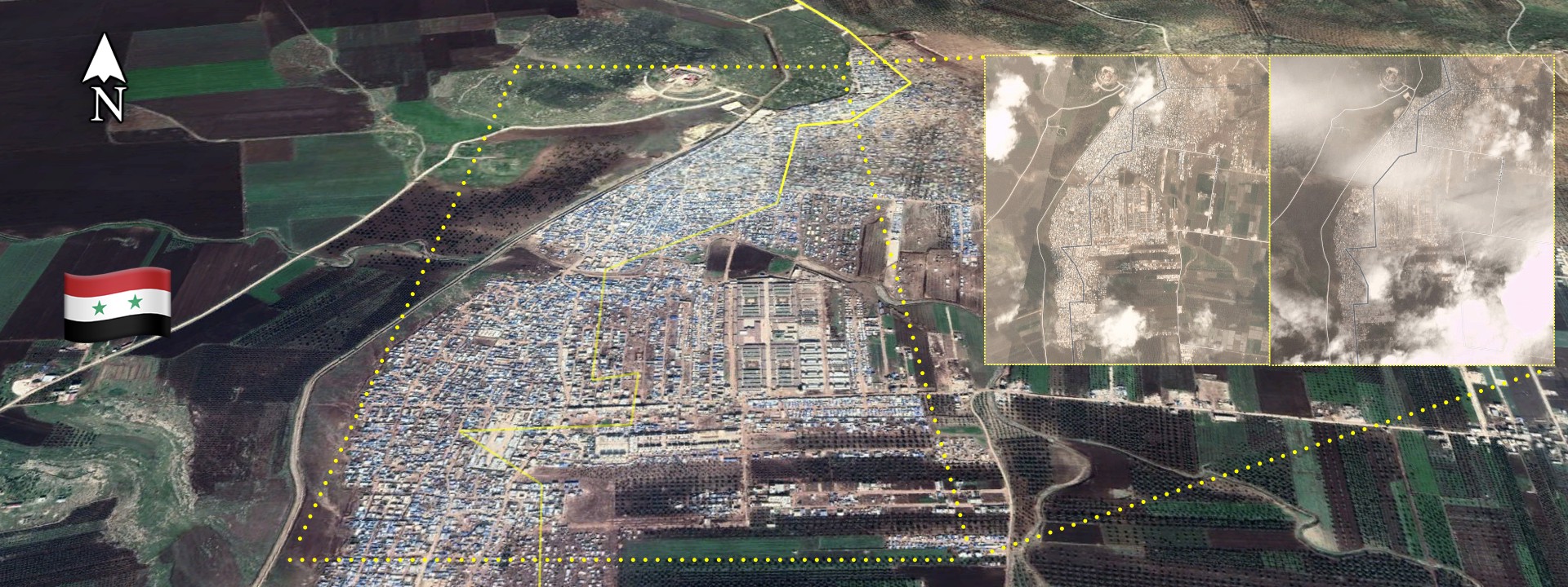
BANNER: (Source: @LAndriukaitis/DFRLab via GoogleMaps, background; Planet.com, top right)
Severe flooding in late March caused extensive damage at the Atmah refugee camp in northwestern Syria, reportedly affecting refugees across the region.
The camp, along the border with Turkey, is currently the largest operational refugee camp in Syria. It appears to have been heavily impacted, having suffered damage to up to 40 percent of its territory, with tents, housing, and personal belongings swept away by the floods. Recent satellite imagery confirms the extent of the flooding.
Outside of Syria, media outlets devoted little coverage to the disaster and its impact on an already vulnerable and displaced population. Amid natural disasters, information spread on social media outlets is often unverified and potentially misleading.
The Flood Damage
The Atmah camp has been active since 2013. Families from the areas of Idlib and Hama, among others, have settled in this camp for years, seeking to escape the bombardment from both the Syrian government forces and the Russian air force.
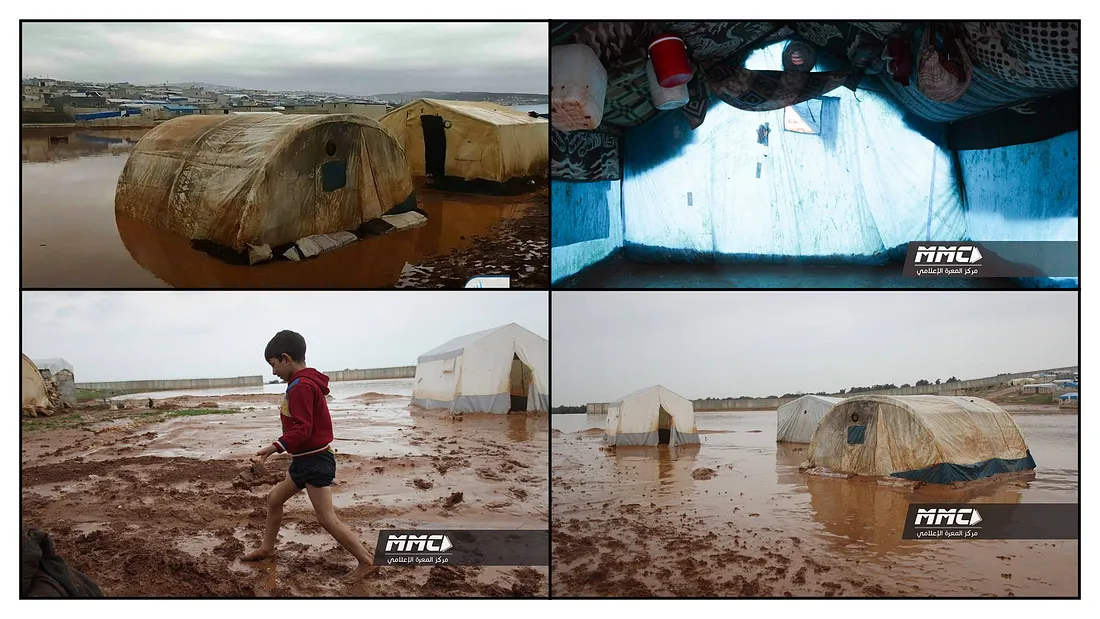
News of the flood damage appeared on various NGO websites in early April, as well as on local Arabic media outlets. These sources provided little visual proof of the damage caused by the floods, however. Conversely, various Twitter accounts provided photographs and videos taken on the ground during the floods.
This visual evidence revealed the full scope of the flood, though it did not indicate the part of the camp at which the photos were taken. While the details in the surfaced photos were insufficient to allow the DFRLab to geolocate the area, satellite imagery taken before and after the weekend of March 30–31 allowed for confirmation that severe floods had devastated the area.
Terrible flooding has hit displacement camps in northwest Syria with more than 8,000 families affected, according to the Response Coordination Group, a local NGO. Recent bombing by the regime and Russia has displaced thousands of families—worsening the already desperate situation pic.twitter.com/yFrx2Qefy0
— The Syria Campaign (@TheSyriaCmpgn) April 1, 2019
#Syria: Atmah refugee camp flooded today following heavy rains. Video shot inside tent belonging to displaced family from #Lataminah (N. #Hama). pic.twitter.com/Xvnvou2NOx
— Qalaat Al Mudiq (@QalaatAlMudiq) March 30, 2019
The aftermath photos revealed large open spaces without tents, covered with mud. These areas were likely previously full of refugee tents that the floodwaters washed away.
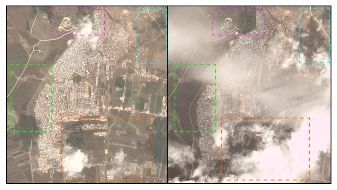
As the lack of distinct landmarks and buildings in the photos and videos made geolocation difficult, the DFRLab used daily satellite imagery to confirm that the flooding took place in Atmah. Comparisons of satellite imagery before and after the weekend of the flood reveal that large areas of the camp area are significantly darker, indicating flooding.
As the conflict in Syria continues, living conditions in refugee camps remain poor, and floods like the one at Atmah are only making the situation worse. The DFRLab will continue to monitor the humanitarian situation in Syria.
Register for the DFRLab’s upcoming 360/OS summit, to be held in London on June 20–21. Join us for two days of interactive sessions and join a growing network of #DigitalSherlocks fighting for facts worldwide!