#BreakingSyria: The Fall of Duma and Eastern Ghouta
A deeper look into the fall of the last rebel-held town in Eastern Ghouta
#BreakingSyria: The Fall of Duma and Eastern Ghouta
A deeper look into the fall of the last rebel-held town in Eastern Ghouta

On Thursday, April 12, the regime of Bashar al-Assad raised its flag over the ruins of what was once the city of Duma (Douma). Rebel forces were wiped out of the area, as Duma was the last standing rebel fortress in Eastern Ghouta. Thousands of people, including rebels and their families, evacuated Duma for areas held by the opposition in northern Syria.
Duma fell soon after Irbin and Harasta were taken in late March and witnessed one of the most gruesome military attacks in the conflict so far, including the possible use of chemical weapon. @DFRLab investigated open source data to see what happened in the last days of rebel-held Duma.
Evidence from Outside of Duma
On April 6, regime sources released a map detailing the encirclement of Duma. The city was under control by Jaysh Al-Islam, a Syrian opposition group that was formed merging 50–60 smaller fighting fractions. These militant were surrounded from all sides.

Before advancing further into the city, regime forces pummeled Duma with artillery relentlessly. A mountain ridge north of Duma was a perfect location to deploy artillery units on an elevated position. Relentless pummeling of the town was recorded in a video by artillery soldiers themselves, and published on April 7. A reverse image search suggested that the video was not posted before.
https://twitter.com/QalaatAlMudiq/status/982597448571879424
The likely location captured in this video is on the mountain ridge, north of the town of Duma. Satellite imagery revealed an artillery position pointing in the direction of rebel controlled area.

As these satellite images were taken months before the April 6 attack, the unit captured in the images is not the same. Nonetheless, a visual comparison suggests that the established artillery position is most likely the same and the artillery unit looks is similar and a useful reference. The artillery position that was established earlier in the conflict was most likely often used to shell Eastern Ghouta. The artillery piece pummelling the town of Duma looks similar to a 130 mm M-46 towed heavy field gun, a tank deployed with this artillery unit is likely a T-55 model tank.

On the same day, pro-regime journalist Hosein Mortada released a different video, filming the attack in real-time on the ground.
#حسين _مرتضى
مشاهد من مشارف دوما ورسالة صباحية خفيفة
وسير المعارك pic.twitter.com/BCC3I0DecV— حسين مرتضى Hussein Mortada (@HoseinMortada) April 7, 2018
Geolocation of the video initially proved problematic, as it only later became apparent that the cameraman was likely using the front-camera of his phone, creating a mirror-effect. The location was quickly confirmed after flipping the video frames horizontally. We found the approximate location on a mountain ridge north of Ghouta and approximately two kilometers south-west from the artillery unit mentioned above.

Evidence from Inside of Duma
On the same day, video footage surfaced from inside the city itself, showing the scope of the destruction from within. One of the earliest geolocatable videos was taken from inside of a car. The driver changed directions while filming as an artillery shell hit a building in front of the car.
E. #Ghouta: moment when an airstrike blew up upper part of a building in #Duma. https://t.co/3cyLJDTF5K pic.twitter.com/1JQuriC3in
— Qalaat Al Mudiq (@QalaatAlMudiq) April 6, 2018
The location of the building was in the eastern part of town. As the artillery shell hit, the car changed the direction back towards the town. Two buildings, which looked similar to military warehouses, served as a clear landmark in the process of geolocation.

This military territory was located in the eastern part of Duma.

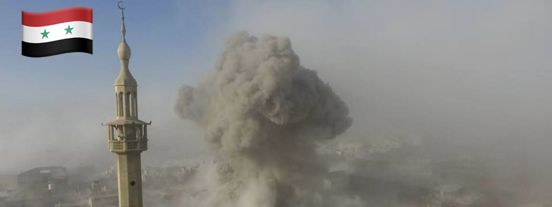
On April 7, a drone video revealed another location where artillery shells hit inside the city. Plumes of smoke and dust shot up next to the mosque in the southern part of Duma.

Open source evidence suggested that on April 8 a ground operation began, as tanks rolled into the eastern part of Duma. One of the videos claimed to have recorded two tanks on the offensive. The video did not provide enough details to identify with absolute certainty, but the equipment in action appeared to be Syrian cage-armor-modified T-72 Mahmia tanks. A reverse image search suggested that this drone footage was not released before and most likely is genuine.
Two mosques, one of which had two domes, helped to geolocate this area. A building with a hexagon shaped roof on the left side confirmed the location.

As the main Assad regime forces were concentrated on the premises of Damascus, the direction of the attack was not surprising.


Each location is pin-pointed on the map below.
Chemical Attack
Reportedly, as the town of Duma was surrounded, regime forces proceeded with bombarding the area with chemical weaponry. These attacks began on April 7, and were recorded in at least three locations. One of the first videos to surface on social media websites showed a gas tank that had fallen through the roof, into a bedroom.
Video for one of the missiles which fall down on #Douma city carrying a chemical gas, dozens were killed and hundreds still suffocating. pic.twitter.com/4Qjr0uxezK
— Asaad Sam Hanna (@AsaadHannaa) April 8, 2018

The gas canister closely resembled a canister from February 13, 2017 attack in Allepo. The color, the metal straps and the valve seemed to coincide with the video footage of April 8.

A team of Bellingcat researchers provided an in-depth open source analysis on the chemical attacks in Duma, confirming the attacks to have happened on April 7.
Conclusion
As rebels were pushed out of Duma, Assad achieved another significant victory in the conflict. Duma, as the last town near Damascus capable of resistance, ended the seven years long military struggle in Eastern Ghouta. As open source evidence suggested, Duma was surrounded completely and the defeat of Jaysh Al-Islam was inevitable.
Gas attacks alone killed at least 70 civilians and affected hundreds and the artillery took at least 130 lives over two days beginning April 7. Assad ended the chapter of Syria’s resistance in Eastern Ghouta using the cruelest methods — cluster bombs, incendiary munitions, topped off with chemical weaponry. The next likely target for Assad is the northern Syria.
@DFRLab will continue to monitor military operations and developments in the Syrian conflict.
Follow along for more in-depth analysis from our #DigitalSherlocks.