#MinskMonitor: Aerial Footage Illuminates Fighting in Donbas
Drone imagery shows ongoing fighting and positions in the Svitlodarsk Bulge andHorlivka
#MinskMonitor: Aerial Footage Illuminates Fighting in Donbas
Drone imagery shows ongoing fighting and positions in the Svitlodarsk Bulge and Horlivka

In one of the few territorial shifts in 2018, the Ukrainian Armed Forces gained control of a small village in northwest Horlivka last week. During that time, government forces defended their pockets of control in this area, along with continued engagement in the so-called “Svitlodarsk Bulge,” northeast of Horlivka. In particular, aerial footage taken from drones help us understand the exact hot spots in this area near Horlivka and Svitlodarsk, with footage showing both Ukrainian and Russian-led separatist positions under attack.
Ongoing Fighting In The Area
Throughout May, the region of Horlivka and the Svitlodarsk Bulge have garnered the bulk of attention from armed formations in Ukraine along with civic monitoring groups. This region lies on the frontline in strategically important locations near the border of the Luhansk Oblast, with several key highways in the area. Below, a map (top) of eastern Ukraine is shown with non-government-controlled areas shaded in red, and another map (bottom) showing the region of Horlivka and the Svitlodarsk Bulge.

A more granular map from the @DFRLab, seen below, closely considers territorial control over trenches and other fortified positions (seen in the red markers scattered throughout the map) in assessing the current situation of territorial control (seen in the red shading).

The OSCE Special Monitoring Mission (SMM) to Ukraine, in its most recent report, described the heavy fighting it recently observed in the area.

A number of civilian casualties in this area have also been reported by the OSCE SMM, including an 86-year-old woman who died on May 18 after shelling in northwest Horlivka and a 76-year-old man who died on May 20 after shelling in Zaitseve (north of Horlivka). Due to restrictions on the OSCE SMM’s movement, especially in non-government-controlled areas, civilian casualty reports are often delayed. For example, on May 30, the OSCE SMM’s work was disrupted when a mortar round was fired a couple hundred meters away from an OSCE patrol south of Donetsk.
As detailed by Nikolaus von Twickel in his weekly newsletter, the “situation in [Horlivka] got so bad that Horlivka’s separatist-appointed mayor, Ivan Prikhodko, denied rumours of an evacuation because of an imminent Ukrainian invasion” and Ukrainian forces were attempting to “cut off Russian supplies for the separatists” near Horlivka.
Aerial Footage of Ukrainian Attacks
It is often difficult to parse through the current situation on the front line given the unreliability of situation and casualty reports from both the Ukrainians and Russian-backed separatists. but drone footage gives us a more verifiable glimpse at the ongoing conflict.
This week, popular Ukrainian military commentator Yury Mysyagin, who often shares “insider” information from the front lines, shared updates and drone footage of Ukrainian activities in the Svitlodarsk Bulge.
On May 28, Mysyagin shared a series of photographs taken from a drone showing an attack from Ukraine’s 54th Brigade in what he described as the Svitlodarsk Bulge. This attack, as he describes it, led to the destruction of a separatist MTLB-ZU — a Soviet-made armored personnel carrier with a ZU-23–2 anti-aircraft gun mounted.


After geolocating these drone photographs, it became clear that the separatist positions are quite a ways from the Svitlodarsk Bulge, but still in the general area, as seen in the red icon in the upper-right (northeast) part of the below satellite image. Svitlodarsk is approximately 20 kilometers southwest of this position.


[facebook url=”https://www.facebook.com/100000828276750/videos/1707285302642396/” /]
This drone footage shows, according to Mysyagin, Ukraine’s 25th Battalion attacking the “Prysh” position. Previous videos have emerged showing Ukrainian attacks on this lake-side position.

This position (Pryshch) is located near the northwest shore of Hryazevskyi pond, which has seen heavy fighting for years, as detailed by the @DFRLab last year. This position can be seen by the red icon in the satellite imagery below.

[facebook url=”https://www.facebook.com/ophidian.asp.1/videos/598331537200902/” /]
https://www.youtube.com/watch?v=4xcIVU8-AcA
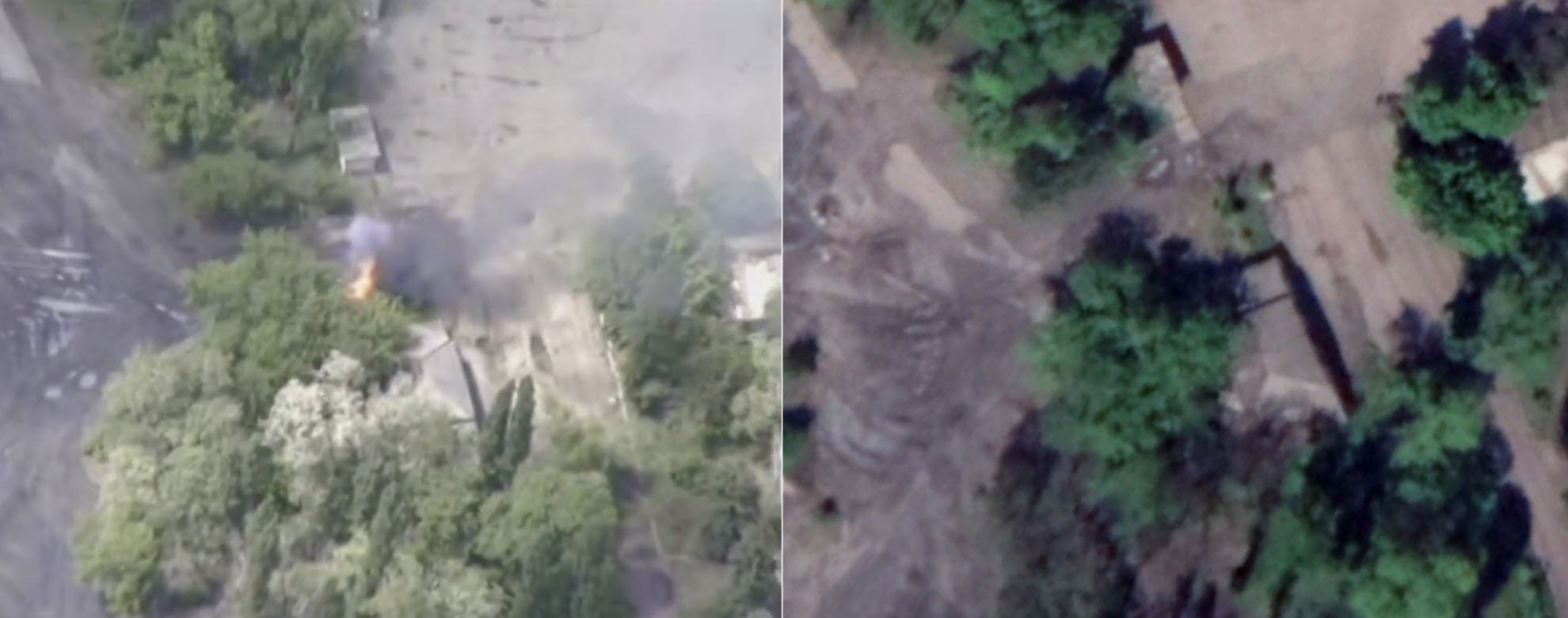
Twitter user @etkmkao geolocated this footage to a Ukrainian position west of Horlivka, near the “Yuzhnaya” mine.
Горящая техника с видео Ophidian Asp (https://t.co/g54oW2cV6H) снята на шахте "Южная", близ Горловки: https://t.co/oc66ibqgsI pic.twitter.com/HcLxpyMTHY
— ETKM/KAO (@etkmkao) May 30, 2018
Comparing satellite imagery from this location pinpointed by @etkmkao and the drone imagery shows a clear match:

Conclusion
Below, the incidents described in this article are compiled together, alongside the areas of territorial control from LiveUAMap. The area shaded in red designates territory not controlled by the Ukrainian government.

With casualty and situational reports from all sides of the Ukrainian conflict unreliable, we increasingly see aerial imagery from drones used to provide a more concrete view of the front lines of eastern Ukraine, especially for the effect of showing successful attacks on enemy positions. Clearly, this is the goal of Yury Mysyagin’s frequent images and videos showing successful Ukrainian operations — but also the responses of other Ukrainians who take issue with his overly-optimistic portrayal of Ukraine’s progress in the Svitlodarsk Bulge.
We will continue to monitor the situation in Horlivka and the Svitlodarsk Bulge, with an eye on aerial imagery showing military positions on both sides of the front line.
Follow the latest Minsk II Violations via the @DFRLab’s #MinskMonitor.
For more in-depth analysis from our regional experts follow the Atlantic Council’s Dinu Patriciu Eurasia Center. Or subscribe to UkraineAlert.